You are here: Home > Network List > IU - Global Seismograph Network (GSN - IRIS/USGS) Stations List
> Station TATO Taipei, Taiwan > Earthquake Result Viewer
TATO Taipei, Taiwan - Earthquake Result Viewer
| Earthquake location: |
Southern Greece |
| Earthquake latitude/longitude: |
36.4/22.1 |
| Earthquake time(UTC): |
1997/10/13 (286) 13:39:37 GMT |
| Earthquake Depth: |
24 km |
| Earthquake Magnitude: |
6.2 MB, 6.6 MS, 6.7 UNKNOWN, 6.5 MW |
| Earthquake Catalog/Contributor: |
WHDF/NEIC |
|
| Network: |
IU Global Seismograph Network (GSN - IRIS/USGS) |
| Station: |
TATO Taipei, Taiwan |
| Lat/Lon: |
24.98 N/121.49 E |
| Elevation: |
53 m |
|
| Distance: |
82.6 deg |
| Az: |
64.526 deg |
| Baz: |
306.607 deg |
| Ray Param: |
0.046722457 |
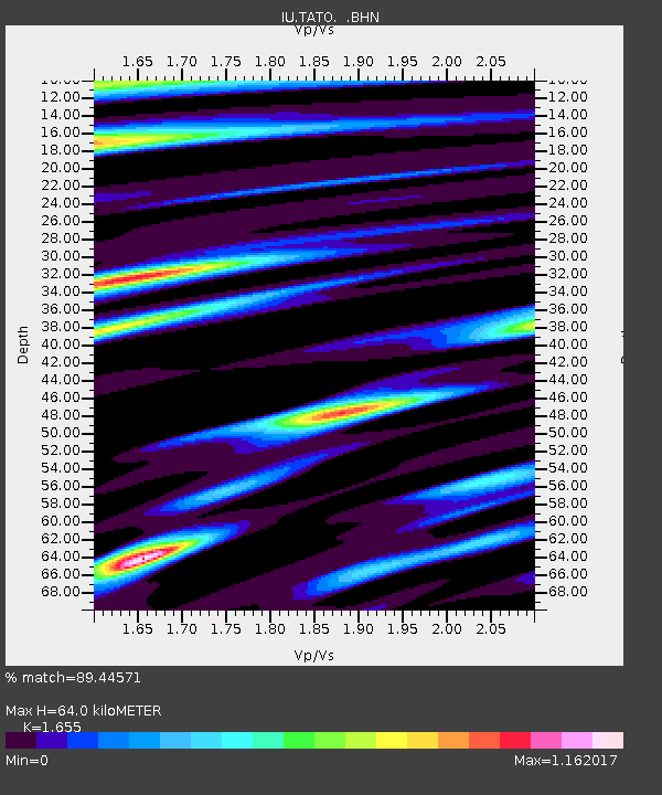
| Estimated Moho Depth: |
64.0 km |
| Estimated Crust Vp/Vs: |
1.65 |
| Assumed Crust Vp: |
6.289 km/s |
| Estimated Crust Vs: |
3.8 km/s |
| Estimated Crust Poisson's Ratio: |
0.21 |
|
| Radial Match: |
89.44571 % |
| Radial Bump: |
400 |
| Transverse Match: |
77.63164 % |
| Transverse Bump: |
400 |
| SOD ConfigId: |
6273 |
| Insert Time: |
2010-03-04 20:59:11.727 +0000 |
| GWidth: |
2.5 |
| Max Bumps: |
400 |
| Tol: |
0.001 |
|

Signal To Noise
| Channel | StoN | STA | LTA |
| IU:TATO: :BHN:19971013T13:51:27.277014Z | 0.7815517 | 2.2400815E-7 | 2.8661975E-7 |
| IU:TATO: :BHE:19971013T13:51:27.277014Z | 1.0178181 | 3.0139307E-7 | 2.9611684E-7 |
| IU:TATO: :BHZ:19971013T13:51:27.277014Z | 4.193542 | 8.720571E-7 | 2.079524E-7 |
| Arrivals |
| Ps | 6.8 SECOND |
| PpPs | 26 SECOND |
| PsPs/PpSs | 33 SECOND |


