You are here: Home > Network List > IU - Global Seismograph Network (GSN - IRIS/USGS) Stations List
> Station TATO Taipei, Taiwan > Earthquake Result Viewer
TATO Taipei, Taiwan - Earthquake Result Viewer
| Earthquake location: |
South Of Fiji Islands |
| Earthquake latitude/longitude: |
-22.1/-176.8 |
| Earthquake time(UTC): |
1997/10/14 (287) 09:53:18 GMT |
| Earthquake Depth: |
167 km |
| Earthquake Magnitude: |
6.7 MB, 7.7 UNKNOWN, 7.4 ME |
| Earthquake Catalog/Contributor: |
WHDF/NEIC |
|
| Network: |
IU Global Seismograph Network (GSN - IRIS/USGS) |
| Station: |
TATO Taipei, Taiwan |
| Lat/Lon: |
24.98 N/121.49 E |
| Elevation: |
53 m |
|
| Distance: |
76.0 deg |
| Az: |
304.537 deg |
| Baz: |
122.673 deg |
| Ray Param: |
0.05084676 |
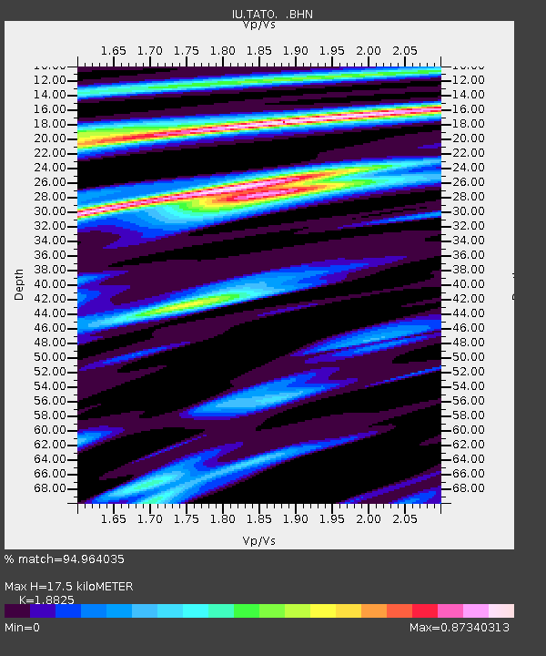
| Estimated Moho Depth: |
17.5 km |
| Estimated Crust Vp/Vs: |
1.88 |
| Assumed Crust Vp: |
6.289 km/s |
| Estimated Crust Vs: |
3.341 km/s |
| Estimated Crust Poisson's Ratio: |
0.30 |
|
| Radial Match: |
94.964035 % |
| Radial Bump: |
345 |
| Transverse Match: |
86.875595 % |
| Transverse Bump: |
400 |
| SOD ConfigId: |
6273 |
| Insert Time: |
2010-03-04 20:59:18.557 +0000 |
| GWidth: |
2.5 |
| Max Bumps: |
400 |
| Tol: |
0.001 |
|
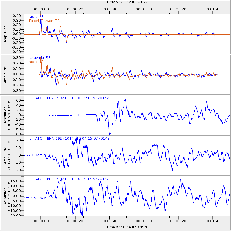
Signal To Noise
| Channel | StoN | STA | LTA |
| IU:TATO: :BHN:19971014T10:04:15.977014Z | 4.9794006 | 1.9904078E-6 | 3.9972844E-7 |
| IU:TATO: :BHE:19971014T10:04:15.977014Z | 5.8454647 | 2.6156983E-6 | 4.474748E-7 |
| IU:TATO: :BHZ:19971014T10:04:15.977014Z | 12.957085 | 1.44868E-5 | 1.1180601E-6 |
| Arrivals |
| Ps | 2.5 SECOND |
| PpPs | 7.8 SECOND |
| PsPs/PpSs | 10 SECOND |


