You are here: Home > Network List > TA - USArray Transportable Network (new EarthScope stations) Stations List
> Station Z41A Richland Creek Farm, El Dorado, AR, USA > Earthquake Result Viewer
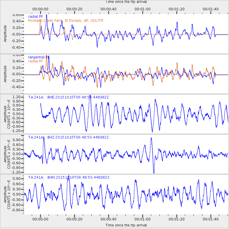
Z41A Richland Creek Farm, El Dorado, AR, USA - Earthquake Result Viewer
*The percent match for this event was below the threshold and hence no stack was calculated.
| Earthquake location: |
Kamchatka Peninsula, Russia |
| Earthquake latitude/longitude: |
55.6/159.2 |
| Earthquake time(UTC): |
2015/10/16 (289) 06:38:26 GMT |
| Earthquake Depth: |
285 km |
| Earthquake Magnitude: |
5.6 MWW, 5.7 MWB |
| Earthquake Catalog/Contributor: |
NEIC PDE/NEIC COMCAT |
|
| Network: |
TA USArray Transportable Network (new EarthScope stations) |
| Station: |
Z41A Richland Creek Farm, El Dorado, AR, USA |
| Lat/Lon: |
33.26 N/92.80 W |
| Elevation: |
62 m |
|
| Distance: |
72.4 deg |
| Az: |
56.734 deg |
| Baz: |
325.5 deg |
| Ray Param: |
$rayparam |
*The percent match for this event was below the threshold and hence was not used in the summary stack. |
|
| Radial Match: |
49.69956 % |
| Radial Bump: |
374 |
| Transverse Match: |
42.8773 % |
| Transverse Bump: |
333 |
| SOD ConfigId: |
7422571 |
| Insert Time: |
2019-04-21 03:08:24.045 +0000 |
| GWidth: |
2.5 |
| Max Bumps: |
400 |
| Tol: |
0.001 |
|
Signal To Noise
| Channel | StoN | STA | LTA |
| TA:Z41A: :BHZ:20151016T06:48:50.448982Z | 2.7717993 | 4.4170724E-7 | 1.5935758E-7 |
| TA:Z41A: :BHN:20151016T06:48:50.448982Z | 0.95344937 | 3.8980718E-7 | 4.088389E-7 |
| TA:Z41A: :BHE:20151016T06:48:50.448982Z | 1.8209013 | 6.708362E-7 | 3.6840888E-7 |
| Arrivals |
| Ps | |
| PpPs | |
| PsPs/PpSs | |


