You are here: Home > Network List > UW - Pacific Northwest Regional Seismic Network Stations List
> Station MRBL Marblemount, WA, USA > Earthquake Result Viewer
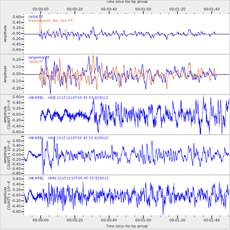
MRBL Marblemount, WA, USA - Earthquake Result Viewer
*The percent match for this event was below the threshold and hence no stack was calculated.
| Earthquake location: |
Kamchatka Peninsula, Russia |
| Earthquake latitude/longitude: |
55.6/159.2 |
| Earthquake time(UTC): |
2015/10/16 (289) 06:38:26 GMT |
| Earthquake Depth: |
285 km |
| Earthquake Magnitude: |
5.6 MWW, 5.7 MWB |
| Earthquake Catalog/Contributor: |
NEIC PDE/NEIC COMCAT |
|
| Network: |
UW Pacific Northwest Regional Seismic Network |
| Station: |
MRBL Marblemount, WA, USA |
| Lat/Lon: |
48.52 N/121.48 W |
| Elevation: |
75 m |
|
| Distance: |
46.8 deg |
| Az: |
63.736 deg |
| Baz: |
310.042 deg |
| Ray Param: |
$rayparam |
*The percent match for this event was below the threshold and hence was not used in the summary stack. |
|
| Radial Match: |
61.21313 % |
| Radial Bump: |
400 |
| Transverse Match: |
61.06711 % |
| Transverse Bump: |
400 |
| SOD ConfigId: |
7422571 |
| Insert Time: |
2019-04-21 03:09:08.801 +0000 |
| GWidth: |
2.5 |
| Max Bumps: |
400 |
| Tol: |
0.001 |
|
Signal To Noise
| Channel | StoN | STA | LTA |
| UW:MRBL: :HHZ:20151016T06:45:56.82801Z | 3.3631935 | 3.5593976E-7 | 1.0583386E-7 |
| UW:MRBL: :HHN:20151016T06:45:56.82801Z | 1.4416735 | 1.431181E-7 | 9.92722E-8 |
| UW:MRBL: :HHE:20151016T06:45:56.82801Z | 2.8822694 | 2.802839E-7 | 9.7244175E-8 |
| Arrivals |
| Ps | |
| PpPs | |
| PsPs/PpSs | |


