You are here: Home > Network List > TA - USArray Transportable Network (new EarthScope stations) Stations List
> Station MSTX Muleshoe, TX, USA > Earthquake Result Viewer
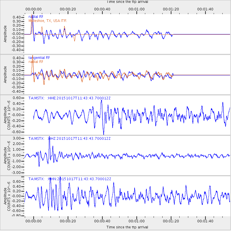
MSTX Muleshoe, TX, USA - Earthquake Result Viewer
*The percent match for this event was below the threshold and hence no stack was calculated.
| Earthquake location: |
Salta Province, Argentina |
| Earthquake latitude/longitude: |
-25.4/-64.4 |
| Earthquake time(UTC): |
2015/10/17 (290) 11:33:07 GMT |
| Earthquake Depth: |
8.2 km |
| Earthquake Magnitude: |
6.0 MB, 5.9 MWB |
| Earthquake Catalog/Contributor: |
NEIC PDE/NEIC COMCAT |
|
| Network: |
TA USArray Transportable Network (new EarthScope stations) |
| Station: |
MSTX Muleshoe, TX, USA |
| Lat/Lon: |
33.97 N/102.77 W |
| Elevation: |
1167 m |
|
| Distance: |
69.4 deg |
| Az: |
326.58 deg |
| Baz: |
143.176 deg |
| Ray Param: |
$rayparam |
*The percent match for this event was below the threshold and hence was not used in the summary stack. |
|
| Radial Match: |
75.19776 % |
| Radial Bump: |
332 |
| Transverse Match: |
58.426575 % |
| Transverse Bump: |
384 |
| SOD ConfigId: |
7422571 |
| Insert Time: |
2019-04-21 03:18:04.464 +0000 |
| GWidth: |
2.5 |
| Max Bumps: |
400 |
| Tol: |
0.001 |
|
Signal To Noise
| Channel | StoN | STA | LTA |
| TA:MSTX: :HHZ:20151017T11:43:43.700012Z | 4.472171 | 5.860922E-7 | 1.3105317E-7 |
| TA:MSTX: :HHN:20151017T11:43:43.700012Z | 1.5125238 | 2.2147277E-7 | 1.4642599E-7 |
| TA:MSTX: :HHE:20151017T11:43:43.700012Z | 1.8545328 | 2.2185499E-7 | 1.196285E-7 |
| Arrivals |
| Ps | |
| PpPs | |
| PsPs/PpSs | |


