You are here: Home > Network List > CI - Caltech Regional Seismic Network Stations List
> Station CIU CATALINA ISLAND > Earthquake Result Viewer
CIU CATALINA ISLAND - Earthquake Result Viewer
| Earthquake location: |
Near Coast Of Guatemala |
| Earthquake latitude/longitude: |
13.7/-90.3 |
| Earthquake time(UTC): |
1997/12/22 (356) 10:03:45 GMT |
| Earthquake Depth: |
59 km |
| Earthquake Magnitude: |
5.1 MB, 6.1 UNKNOWN, 5.2 MD |
| Earthquake Catalog/Contributor: |
WHDF/NEIC |
|
| Network: |
CI Caltech Regional Seismic Network |
| Station: |
CIU CATALINA ISLAND |
| Lat/Lon: |
33.45 N/118.48 W |
| Elevation: |
203 m |
|
| Distance: |
32.2 deg |
| Az: |
312.296 deg |
| Baz: |
120.72 deg |
| Ray Param: |
0.07860215 |
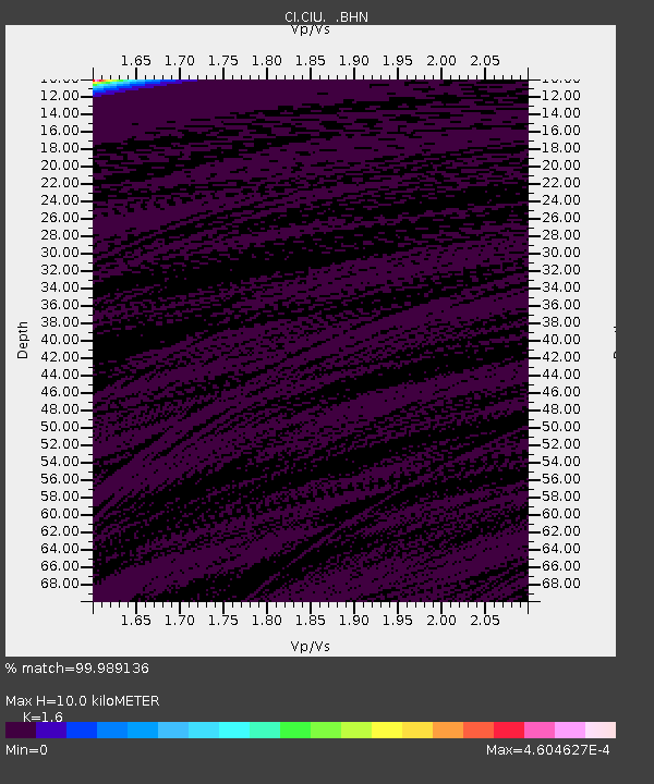
| Estimated Moho Depth: |
10.0 km |
| Estimated Crust Vp/Vs: |
1.60 |
| Assumed Crust Vp: |
6.048 km/s |
| Estimated Crust Vs: |
3.78 km/s |
| Estimated Crust Poisson's Ratio: |
0.18 |
|
| Radial Match: |
99.989136 % |
| Radial Bump: |
2 |
| Transverse Match: |
99.938866 % |
| Transverse Bump: |
5 |
| SOD ConfigId: |
3770 |
| Insert Time: |
2010-02-25 23:51:24.574 +0000 |
| GWidth: |
2.5 |
| Max Bumps: |
400 |
| Tol: |
0.001 |
|
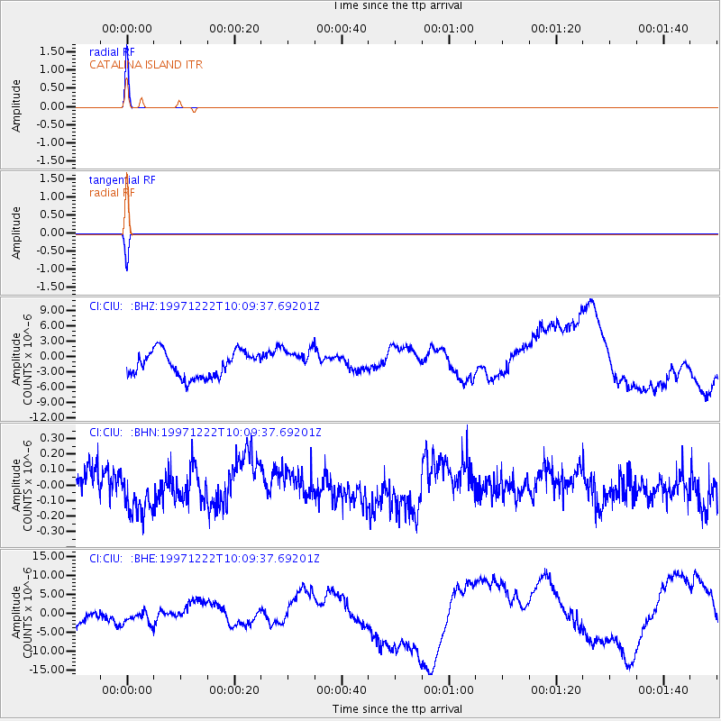
Signal To Noise
| Channel | StoN | STA | LTA |
| CI:CIU: :BHN:19971222T10:09:37.69201Z | 1.695544 | 1.437226E-7 | 8.476489E-8 |
| CI:CIU: :BHE:19971222T10:09:37.69201Z | 1.0271127 | 3.575613E-6 | 3.4812272E-6 |
| CI:CIU: :BHZ:19971222T10:09:37.69201Z | 1.0211287 | 2.5128331E-6 | 2.4608391E-6 |
| Arrivals |
| Ps | 1.1 SECOND |
| PpPs | 4.0 SECOND |
| PsPs/PpSs | 5.1 SECOND |


