You are here: Home > Network List > TA - USArray Transportable Network (new EarthScope stations) Stations List
> Station O48A Farmland, IN, USA > Earthquake Result Viewer
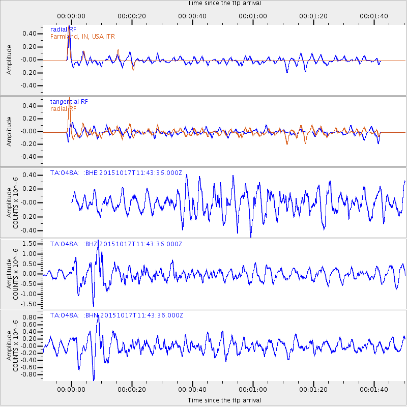
O48A Farmland, IN, USA - Earthquake Result Viewer
*The percent match for this event was below the threshold and hence no stack was calculated.
| Earthquake location: |
Salta Province, Argentina |
| Earthquake latitude/longitude: |
-25.4/-64.4 |
| Earthquake time(UTC): |
2015/10/17 (290) 11:33:07 GMT |
| Earthquake Depth: |
8.2 km |
| Earthquake Magnitude: |
6.0 MB, 5.9 MWB |
| Earthquake Catalog/Contributor: |
NEIC PDE/NEIC COMCAT |
|
| Network: |
TA USArray Transportable Network (new EarthScope stations) |
| Station: |
O48A Farmland, IN, USA |
| Lat/Lon: |
40.26 N/85.16 W |
| Elevation: |
300 m |
|
| Distance: |
68.1 deg |
| Az: |
343.037 deg |
| Baz: |
159.831 deg |
| Ray Param: |
$rayparam |
*The percent match for this event was below the threshold and hence was not used in the summary stack. |
|
| Radial Match: |
73.25448 % |
| Radial Bump: |
357 |
| Transverse Match: |
61.735863 % |
| Transverse Bump: |
400 |
| SOD ConfigId: |
7422571 |
| Insert Time: |
2019-04-21 03:18:08.916 +0000 |
| GWidth: |
2.5 |
| Max Bumps: |
400 |
| Tol: |
0.001 |
|
Signal To Noise
| Channel | StoN | STA | LTA |
| TA:O48A: :BHZ:20151017T11:43:36.000Z | 4.005924 | 4.9869465E-7 | 1.2448928E-7 |
| TA:O48A: :BHN:20151017T11:43:36.000Z | 1.6709491 | 2.7474323E-7 | 1.6442344E-7 |
| TA:O48A: :BHE:20151017T11:43:36.000Z | 0.7602453 | 7.500269E-8 | 9.8655896E-8 |
| Arrivals |
| Ps | |
| PpPs | |
| PsPs/PpSs | |


