You are here: Home > Network List > CI - Caltech Regional Seismic Network Stations List
> Station CIU CATALINA ISLAND > Earthquake Result Viewer
CIU CATALINA ISLAND - Earthquake Result Viewer
| Earthquake location: |
Colombia |
| Earthquake latitude/longitude: |
3.9/-75.8 |
| Earthquake time(UTC): |
1997/12/11 (345) 07:56:28 GMT |
| Earthquake Depth: |
178 km |
| Earthquake Magnitude: |
6.0 MB, 6.4 UNKNOWN, 6.3 MW |
| Earthquake Catalog/Contributor: |
WHDF/NEIC |
|
| Network: |
CI Caltech Regional Seismic Network |
| Station: |
CIU CATALINA ISLAND |
| Lat/Lon: |
33.45 N/118.48 W |
| Elevation: |
203 m |
|
| Distance: |
49.4 deg |
| Az: |
311.718 deg |
| Baz: |
117.042 deg |
| Ray Param: |
0.06807241 |
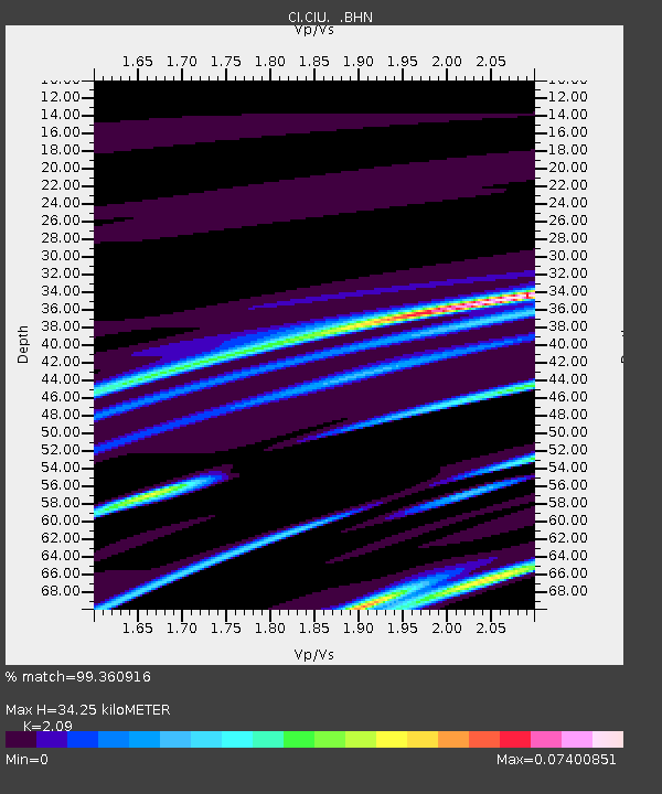
| Estimated Moho Depth: |
34.25 km |
| Estimated Crust Vp/Vs: |
2.09 |
| Assumed Crust Vp: |
6.048 km/s |
| Estimated Crust Vs: |
2.894 km/s |
| Estimated Crust Poisson's Ratio: |
0.35 |
|
| Radial Match: |
99.360916 % |
| Radial Bump: |
46 |
| Transverse Match: |
97.158905 % |
| Transverse Bump: |
198 |
| SOD ConfigId: |
3770 |
| Insert Time: |
2010-02-25 23:51:26.817 +0000 |
| GWidth: |
2.5 |
| Max Bumps: |
400 |
| Tol: |
0.001 |
|
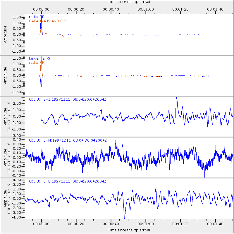
Signal To Noise
| Channel | StoN | STA | LTA |
| CI:CIU: :BHN:19971211T08:04:30.042004Z | 1.3561952 | 1.1757952E-7 | 8.669808E-8 |
| CI:CIU: :BHE:19971211T08:04:30.042004Z | 1.5019314 | 1.0155845E-6 | 6.7618566E-7 |
| CI:CIU: :BHZ:19971211T08:04:30.042004Z | 1.448335 | 6.821687E-7 | 4.71002E-7 |
| Arrivals |
| Ps | 6.4 SECOND |
| PpPs | 17 SECOND |
| PsPs/PpSs | 23 SECOND |


