You are here: Home > Network List > TA - USArray Transportable Network (new EarthScope stations) Stations List
> Station O03E Paynes Creek, CA, USA > Earthquake Result Viewer
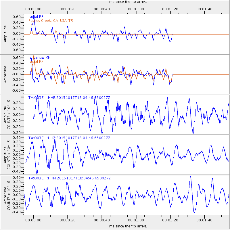
O03E Paynes Creek, CA, USA - Earthquake Result Viewer
*The percent match for this event was below the threshold and hence no stack was calculated.
| Earthquake location: |
West Chile Rise |
| Earthquake latitude/longitude: |
-42.6/-82.4 |
| Earthquake time(UTC): |
2015/10/17 (290) 17:52:20 GMT |
| Earthquake Depth: |
11 km |
| Earthquake Magnitude: |
5.6 MWW, 5.6 MWB, 5.6 MWC |
| Earthquake Catalog/Contributor: |
NEIC PDE/NEIC COMCAT |
|
| Network: |
TA USArray Transportable Network (new EarthScope stations) |
| Station: |
O03E Paynes Creek, CA, USA |
| Lat/Lon: |
40.29 N/121.80 W |
| Elevation: |
967 m |
|
| Distance: |
89.9 deg |
| Az: |
330.988 deg |
| Baz: |
152.096 deg |
| Ray Param: |
$rayparam |
*The percent match for this event was below the threshold and hence was not used in the summary stack. |
|
| Radial Match: |
66.39777 % |
| Radial Bump: |
400 |
| Transverse Match: |
62.179543 % |
| Transverse Bump: |
400 |
| SOD ConfigId: |
7422571 |
| Insert Time: |
2019-04-21 03:25:30.572 +0000 |
| GWidth: |
2.5 |
| Max Bumps: |
400 |
| Tol: |
0.001 |
|
Signal To Noise
| Channel | StoN | STA | LTA |
| TA:O03E: :HHZ:20151017T18:04:46.650027Z | 1.6752702 | 2.5792363E-7 | 1.5395942E-7 |
| TA:O03E: :HHN:20151017T18:04:46.650027Z | 1.2832828 | 1.5892407E-7 | 1.238418E-7 |
| TA:O03E: :HHE:20151017T18:04:46.650027Z | 1.2803298 | 1.4580824E-7 | 1.1388334E-7 |
| Arrivals |
| Ps | |
| PpPs | |
| PsPs/PpSs | |


