You are here: Home > Network List > TA - USArray Transportable Network (new EarthScope stations) Stations List
> Station O48A Farmland, IN, USA > Earthquake Result Viewer
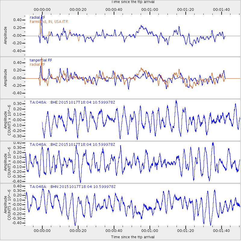
O48A Farmland, IN, USA - Earthquake Result Viewer
*The percent match for this event was below the threshold and hence no stack was calculated.
| Earthquake location: |
West Chile Rise |
| Earthquake latitude/longitude: |
-42.6/-82.4 |
| Earthquake time(UTC): |
2015/10/17 (290) 17:52:20 GMT |
| Earthquake Depth: |
11 km |
| Earthquake Magnitude: |
5.6 MWW, 5.6 MWB, 5.6 MWC |
| Earthquake Catalog/Contributor: |
NEIC PDE/NEIC COMCAT |
|
| Network: |
TA USArray Transportable Network (new EarthScope stations) |
| Station: |
O48A Farmland, IN, USA |
| Lat/Lon: |
40.26 N/85.16 W |
| Elevation: |
300 m |
|
| Distance: |
82.5 deg |
| Az: |
357.912 deg |
| Baz: |
177.986 deg |
| Ray Param: |
$rayparam |
*The percent match for this event was below the threshold and hence was not used in the summary stack. |
|
| Radial Match: |
33.212788 % |
| Radial Bump: |
400 |
| Transverse Match: |
52.656994 % |
| Transverse Bump: |
400 |
| SOD ConfigId: |
7422571 |
| Insert Time: |
2019-04-21 03:25:31.244 +0000 |
| GWidth: |
2.5 |
| Max Bumps: |
400 |
| Tol: |
0.001 |
|
Signal To Noise
| Channel | StoN | STA | LTA |
| TA:O48A: :BHZ:20151017T18:04:10.599978Z | 1.6980736 | 2.1564713E-7 | 1.2699516E-7 |
| TA:O48A: :BHN:20151017T18:04:10.599978Z | 1.4755869 | 2.6579355E-7 | 1.8012734E-7 |
| TA:O48A: :BHE:20151017T18:04:10.599978Z | 0.90730196 | 1.206214E-7 | 1.3294515E-7 |
| Arrivals |
| Ps | |
| PpPs | |
| PsPs/PpSs | |


