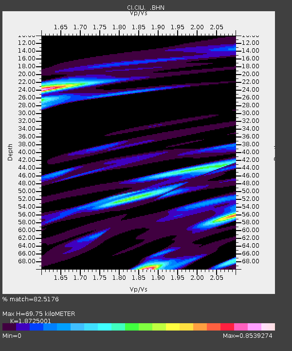
CIU CATALINA ISLAND - Earthquake Result Viewer
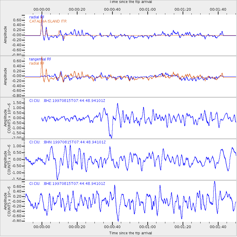
Earthquake location: Central East Pacific Rise
Earthquake latitude/longitude: -4.4/-105.7
Earthquake time(UTC): 1997/08/15 (227) 07:37:49 GMT
Earthquake Depth: 10 km
Earthquake Magnitude: 5.3 MB, 5.8 MS, 6.2 UNKNOWN, 6.1 MW
Earthquake Catalog/Contributor: WHDF/NEIC
Network: CI Caltech Regional Seismic Network
Station: CIU CATALINA ISLAND
Lat/Lon: 33.45 N/118.48 W
Elevation: 203 m
Distance: 39.5 deg
Az: 343.094 deg
Baz: 159.708 deg
Ray Param: 0.07494108
Estimated Moho Depth: 69.75 km
Estimated Crust Vp/Vs: 1.87
Assumed Crust Vp: 6.048 km/s
Estimated Crust Vs: 3.23 km/s
Estimated Crust Poisson's Ratio: 0.30
Radial Match: 82.5176 %
Radial Bump: 400
Transverse Match: 52.614147 %
Transverse Bump: 400
SOD ConfigId: 4770
Insert Time: 2010-02-25 23:51:33.353 +0000
GWidth: 2.5
Max Bumps: 400
Tol: 0.001

Signal To Noise

ChannelStoNSTALTA
CI:CIU: :BHN:19970815T07:44:48.94101Z1.75667732.6084913E-71.4849009E-7
CI:CIU: :BHE:19970815T07:44:48.94101Z2.41498113.1515745E-71.3050101E-7
CI:CIU: :BHZ:19970815T07:44:48.94101Z2.0397792.9040993E-71.4237324E-7
Arrivals
Ps11 SECOND
PpPs31 SECOND
PsPs/PpSs42 SECOND