You are here: Home > Network List > IU - Global Seismograph Network (GSN - IRIS/USGS) Stations List
> Station TOL Toledo, Spain > Earthquake Result Viewer
TOL Toledo, Spain - Earthquake Result Viewer
| Earthquake location: |
Fox Islands, Aleutian Islands |
| Earthquake latitude/longitude: |
54.3/-169.3 |
| Earthquake time(UTC): |
1991/08/14 (226) 12:53:28 GMT |
| Earthquake Depth: |
299 km |
| Earthquake Magnitude: |
5.7 MB, 6.1 UNKNOWN |
| Earthquake Catalog/Contributor: |
WHDF/NEIC |
|
| Network: |
IU Global Seismograph Network (GSN - IRIS/USGS) |
| Station: |
TOL Toledo, Spain |
| Lat/Lon: |
39.88 N/4.05 W |
| Elevation: |
480 m |
|
| Distance: |
85.3 deg |
| Az: |
11.303 deg |
| Baz: |
351.421 deg |
| Ray Param: |
0.044111703 |
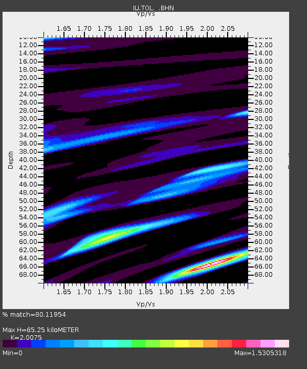
| Estimated Moho Depth: |
65.25 km |
| Estimated Crust Vp/Vs: |
2.01 |
| Assumed Crust Vp: |
6.276 km/s |
| Estimated Crust Vs: |
3.126 km/s |
| Estimated Crust Poisson's Ratio: |
0.33 |
|
| Radial Match: |
80.11954 % |
| Radial Bump: |
400 |
| Transverse Match: |
56.06523 % |
| Transverse Bump: |
400 |
| SOD ConfigId: |
16938 |
| Insert Time: |
2010-03-04 21:03:38.968 +0000 |
| GWidth: |
2.5 |
| Max Bumps: |
400 |
| Tol: |
0.001 |
|
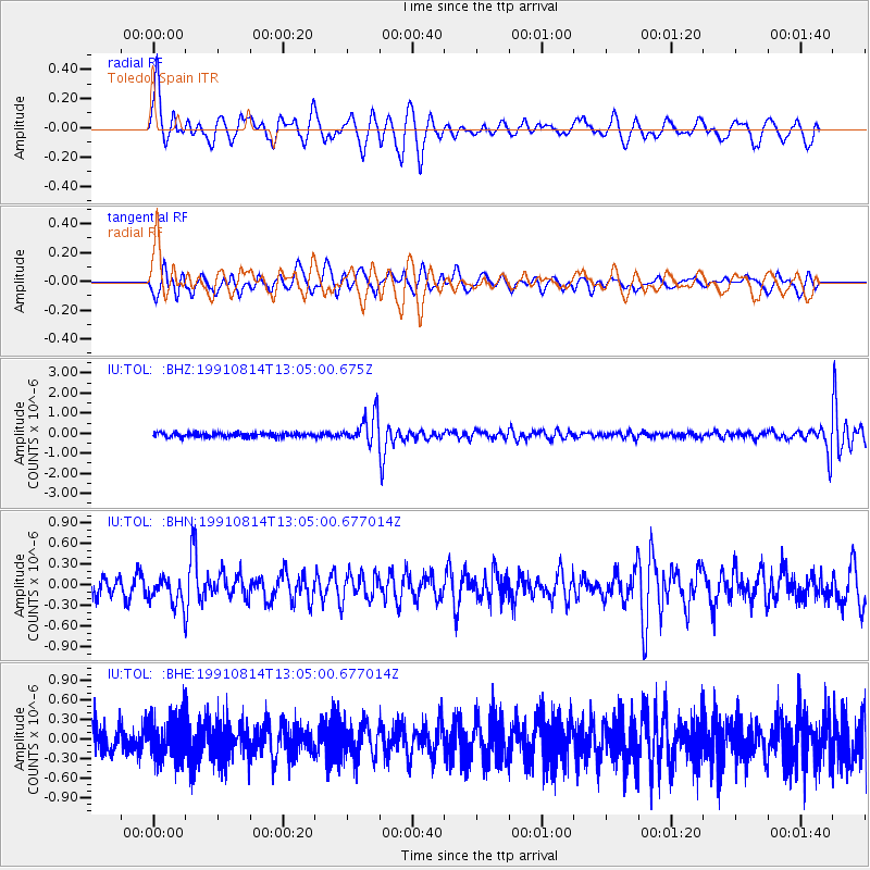
Signal To Noise
| Channel | StoN | STA | LTA |
| IU:TOL: :BHN:19910814T13:05:00.677014Z | 1.6374025 | 2.106533E-7 | 1.286509E-7 |
| IU:TOL: :BHE:19910814T13:05:00.677014Z | 1.0902779 | 3.2939576E-7 | 3.0212092E-7 |
| IU:TOL: :BHZ:19910814T13:05:00.675Z | 6.760213 | 7.133202E-7 | 1.05517415E-7 |
| Arrivals |
| Ps | 11 SECOND |
| PpPs | 31 SECOND |
| PsPs/PpSs | 41 SECOND |


