You are here: Home > Network List > IU - Global Seismograph Network (GSN - IRIS/USGS) Stations List
> Station TOL Toledo, Spain > Earthquake Result Viewer
TOL Toledo, Spain - Earthquake Result Viewer
| Earthquake location: |
Near Coast Of Northern Calif. |
| Earthquake latitude/longitude: |
40.2/-124.3 |
| Earthquake time(UTC): |
1991/08/17 (229) 19:29:40 GMT |
| Earthquake Depth: |
12 km |
| Earthquake Magnitude: |
6.1 MB, 6.0 MS, 6.0 ML |
| Earthquake Catalog/Contributor: |
WHDF/NEIC |
|
| Network: |
IU Global Seismograph Network (GSN - IRIS/USGS) |
| Station: |
TOL Toledo, Spain |
| Lat/Lon: |
39.88 N/4.05 W |
| Elevation: |
480 m |
|
| Distance: |
83.5 deg |
| Az: |
41.968 deg |
| Baz: |
318.296 deg |
| Ray Param: |
0.04616161 |
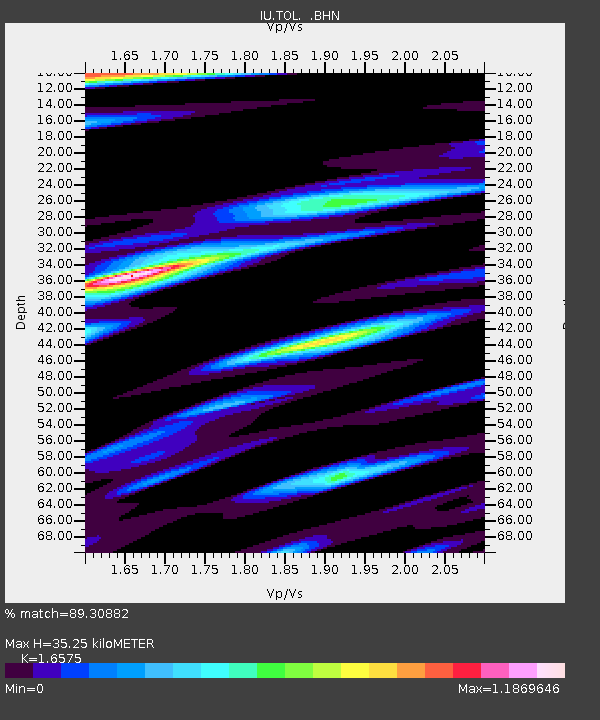
| Estimated Moho Depth: |
35.25 km |
| Estimated Crust Vp/Vs: |
1.66 |
| Assumed Crust Vp: |
6.276 km/s |
| Estimated Crust Vs: |
3.786 km/s |
| Estimated Crust Poisson's Ratio: |
0.21 |
|
| Radial Match: |
89.30882 % |
| Radial Bump: |
357 |
| Transverse Match: |
87.18788 % |
| Transverse Bump: |
400 |
| SOD ConfigId: |
16938 |
| Insert Time: |
2010-03-04 21:03:41.172 +0000 |
| GWidth: |
2.5 |
| Max Bumps: |
400 |
| Tol: |
0.001 |
|
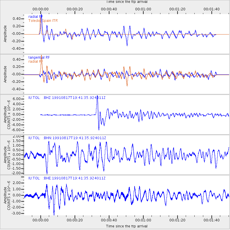
Signal To Noise
| Channel | StoN | STA | LTA |
| IU:TOL: :BHN:19910817T19:41:35.924011Z | 3.6372902 | 7.71056E-7 | 2.1198639E-7 |
| IU:TOL: :BHE:19910817T19:41:35.924011Z | 4.02891 | 7.227643E-7 | 1.793945E-7 |
| IU:TOL: :BHZ:19910817T19:41:35.924011Z | 47.10536 | 2.8537286E-6 | 6.058182E-8 |
| Arrivals |
| Ps | 3.8 SECOND |
| PpPs | 15 SECOND |
| PsPs/PpSs | 18 SECOND |


