You are here: Home > Network List > IU - Global Seismograph Network (GSN - IRIS/USGS) Stations List
> Station TOL Toledo, Spain > Earthquake Result Viewer
TOL Toledo, Spain - Earthquake Result Viewer
| Earthquake location: |
Off Coast Of Northern California |
| Earthquake latitude/longitude: |
41.6/-125.5 |
| Earthquake time(UTC): |
1991/08/17 (229) 22:17:12 GMT |
| Earthquake Depth: |
10 km |
| Earthquake Magnitude: |
6.2 MB, 7.1 MS, 6.8 ML |
| Earthquake Catalog/Contributor: |
WHDF/NEIC |
|
| Network: |
IU Global Seismograph Network (GSN - IRIS/USGS) |
| Station: |
TOL Toledo, Spain |
| Lat/Lon: |
39.88 N/4.05 W |
| Elevation: |
480 m |
|
| Distance: |
83.0 deg |
| Az: |
41.397 deg |
| Baz: |
319.873 deg |
| Ray Param: |
0.046475075 |
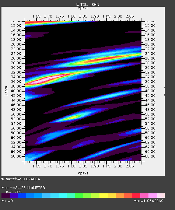
| Estimated Moho Depth: |
34.25 km |
| Estimated Crust Vp/Vs: |
1.71 |
| Assumed Crust Vp: |
6.276 km/s |
| Estimated Crust Vs: |
3.681 km/s |
| Estimated Crust Poisson's Ratio: |
0.24 |
|
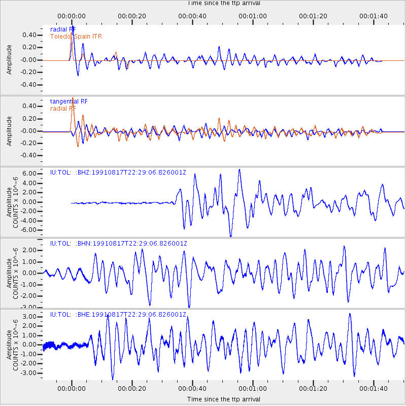
| Radial Match: |
93.874084 % |
| Radial Bump: |
400 |
| Transverse Match: |
82.19437 % |
| Transverse Bump: |
400 |
| SOD ConfigId: |
16938 |
| Insert Time: |
2010-03-04 21:03:42.634 +0000 |
| GWidth: |
2.5 |
| Max Bumps: |
400 |
| Tol: |
0.001 |
|
Signal To Noise
| Channel | StoN | STA | LTA |
| IU:TOL: :BHN:19910817T22:29:06.826001Z | 2.2232895 | 3.4545533E-7 | 1.5538029E-7 |
| IU:TOL: :BHE:19910817T22:29:06.826001Z | 0.5359896 | 1.4910681E-7 | 2.7818973E-7 |
| IU:TOL: :BHZ:19910817T22:29:06.826001Z | 3.1612234 | 2.7843777E-7 | 8.807911E-8 |
| Arrivals |
| Ps | 3.9 SECOND |
| PpPs | 14 SECOND |
| PsPs/PpSs | 18 SECOND |


