You are here: Home > Network List > IU - Global Seismograph Network (GSN - IRIS/USGS) Stations List
> Station TOL Toledo, Spain > Earthquake Result Viewer
TOL Toledo, Spain - Earthquake Result Viewer
| Earthquake location: |
Near Coast Of Northern Calif. |
| Earthquake latitude/longitude: |
40.4/-124.3 |
| Earthquake time(UTC): |
1992/04/25 (116) 18:06:04 GMT |
| Earthquake Depth: |
15 km |
| Earthquake Magnitude: |
6.4 MB, 7.1 MS |
| Earthquake Catalog/Contributor: |
WHDF/NEIC |
|
| Network: |
IU Global Seismograph Network (GSN - IRIS/USGS) |
| Station: |
TOL Toledo, Spain |
| Lat/Lon: |
39.88 N/4.05 W |
| Elevation: |
480 m |
|
| Distance: |
83.4 deg |
| Az: |
41.997 deg |
| Baz: |
318.367 deg |
| Ray Param: |
0.0462383 |
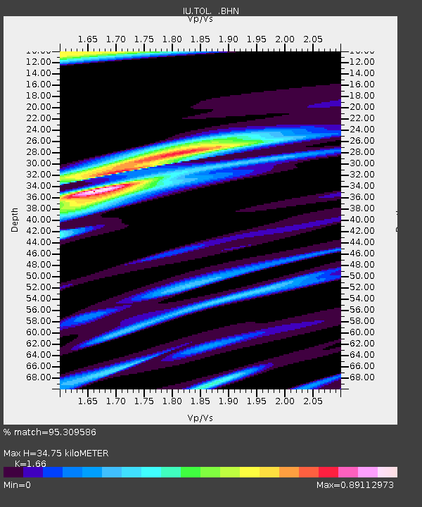
| Estimated Moho Depth: |
34.75 km |
| Estimated Crust Vp/Vs: |
1.66 |
| Assumed Crust Vp: |
6.276 km/s |
| Estimated Crust Vs: |
3.781 km/s |
| Estimated Crust Poisson's Ratio: |
0.22 |
|
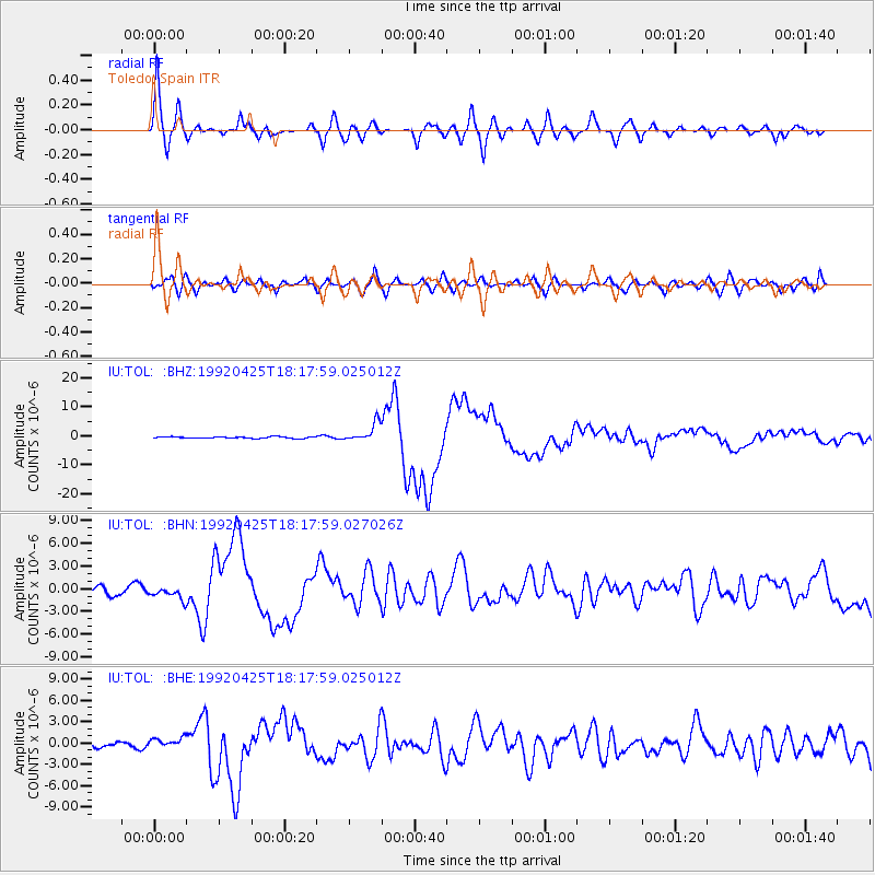
| Radial Match: |
95.309586 % |
| Radial Bump: |
400 |
| Transverse Match: |
79.336296 % |
| Transverse Bump: |
400 |
| SOD ConfigId: |
16938 |
| Insert Time: |
2010-03-04 21:03:50.354 +0000 |
| GWidth: |
2.5 |
| Max Bumps: |
400 |
| Tol: |
0.001 |
|
Signal To Noise
| Channel | StoN | STA | LTA |
| IU:TOL: :BHN:19920425T18:17:59.027026Z | 1.6109252 | 8.522457E-7 | 5.290412E-7 |
| IU:TOL: :BHE:19920425T18:17:59.025012Z | 1.4282767 | 6.9900267E-7 | 4.8940285E-7 |
| IU:TOL: :BHZ:19920425T18:17:59.025012Z | 11.380069 | 3.19485E-6 | 2.8074084E-7 |
| Arrivals |
| Ps | 3.8 SECOND |
| PpPs | 14 SECOND |
| PsPs/PpSs | 18 SECOND |


