You are here: Home > Network List > IU - Global Seismograph Network (GSN - IRIS/USGS) Stations List
> Station TOL Toledo, Spain > Earthquake Result Viewer
TOL Toledo, Spain - Earthquake Result Viewer
| Earthquake location: |
Near Coast Of Northern Calif. |
| Earthquake latitude/longitude: |
40.4/-124.6 |
| Earthquake time(UTC): |
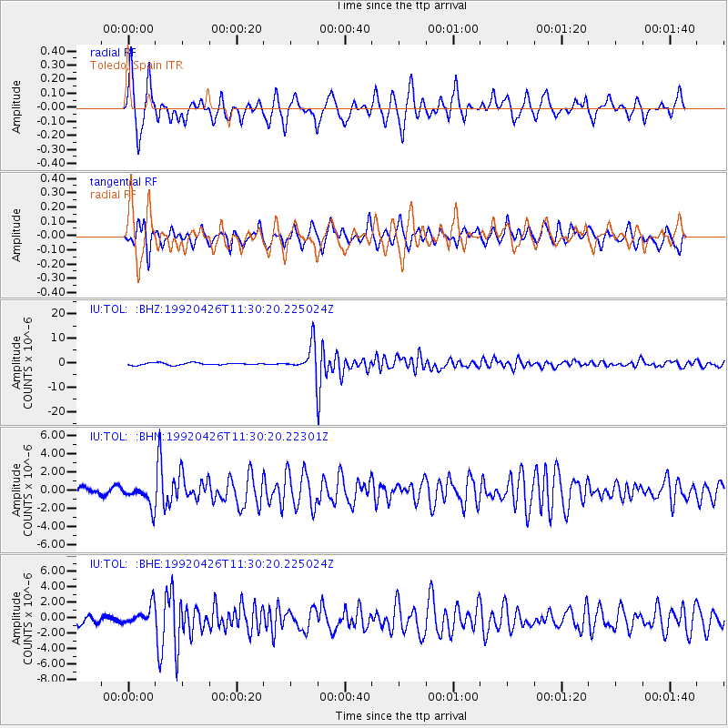
1992/04/26 (117) 11:18:25 GMT |
| Earthquake Depth: |
22 km |
| Earthquake Magnitude: |
6.6 MB, 6.7 MS |
| Earthquake Catalog/Contributor: |
WHDF/NEIC |
|
| Network: |
IU Global Seismograph Network (GSN - IRIS/USGS) |
| Station: |
TOL Toledo, Spain |
| Lat/Lon: |
39.88 N/4.05 W |
| Elevation: |
480 m |
|
| Distance: |
83.5 deg |
| Az: |
41.847 deg |
| Baz: |
318.522 deg |
| Ray Param: |
0.04613636 |
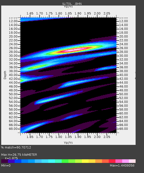
| Estimated Moho Depth: |
26.75 km |
| Estimated Crust Vp/Vs: |
1.88 |
| Assumed Crust Vp: |
6.276 km/s |
| Estimated Crust Vs: |
3.347 km/s |
| Estimated Crust Poisson's Ratio: |
0.30 |
|
| Radial Match: |
90.70712 % |
| Radial Bump: |
330 |
| Transverse Match: |
80.534676 % |
| Transverse Bump: |
400 |
| SOD ConfigId: |
16938 |
| Insert Time: |
2010-03-04 21:03:52.239 +0000 |
| GWidth: |
2.5 |
| Max Bumps: |
400 |
| Tol: |
0.001 |
|
Signal To Noise
| Channel | StoN | STA | LTA |
| IU:TOL: :BHN:19920426T11:30:20.22301Z | 2.052192 | 1.2464487E-6 | 6.073744E-7 |
| IU:TOL: :BHE:19920426T11:30:20.225024Z | 2.6351018 | 1.2679809E-6 | 4.811886E-7 |
| IU:TOL: :BHZ:19920426T11:30:20.225024Z | 12.830783 | 5.8913606E-6 | 4.591583E-7 |
| Arrivals |
| Ps | 3.8 SECOND |
| PpPs | 12 SECOND |
| PsPs/PpSs | 16 SECOND |


