You are here: Home > Network List > WY - Yellowstone Wyoming Seismic Network Stations List
> Station YHH Holmes Hill, YNP, WY, USA > Earthquake Result Viewer
YHH Holmes Hill, YNP, WY, USA - Earthquake Result Viewer
| Earthquake location: |
Northern Chile |
| Earthquake latitude/longitude: |
-22.1/-68.4 |
| Earthquake time(UTC): |
2015/05/26 (146) 10:32:01 GMT |
| Earthquake Depth: |
115 km |
| Earthquake Magnitude: |
5.7 MB |
| Earthquake Catalog/Contributor: |
NEIC PDE/NEIC COMCAT |
|
| Network: |
WY Yellowstone Wyoming Seismic Network |
| Station: |
YHH Holmes Hill, YNP, WY, USA |
| Lat/Lon: |
44.79 N/110.85 W |
| Elevation: |
2717 m |
|
| Distance: |
77.0 deg |
| Az: |
330.464 deg |
| Baz: |
140.044 deg |
| Ray Param: |
0.050364062 |
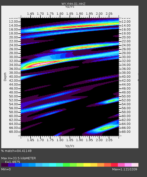
| Estimated Moho Depth: |
33.5 km |
| Estimated Crust Vp/Vs: |
1.70 |
| Assumed Crust Vp: |
6.35 km/s |
| Estimated Crust Vs: |
3.741 km/s |
| Estimated Crust Poisson's Ratio: |
0.23 |
|
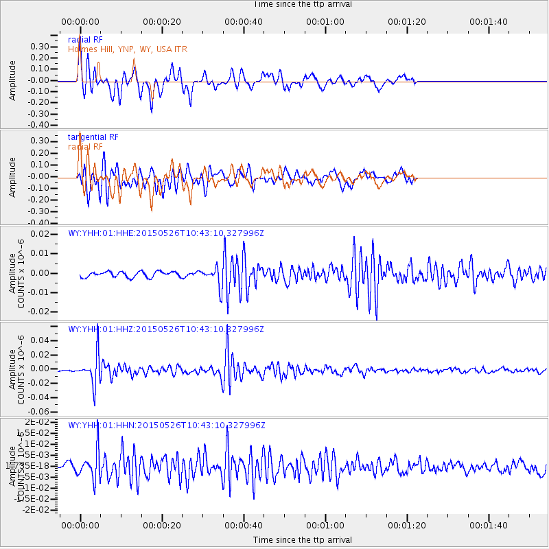
| Radial Match: |
84.41149 % |
| Radial Bump: |
396 |
| Transverse Match: |
82.89994 % |
| Transverse Bump: |
377 |
| SOD ConfigId: |
976571 |
| Insert Time: |
2015-06-09 11:20:43.349 +0000 |
| GWidth: |
2.5 |
| Max Bumps: |
400 |
| Tol: |
0.001 |
|
Signal To Noise
| Channel | StoN | STA | LTA |
| WY:YHH:01:HHZ:20150526T10:43:10.327996Z | 14.961259 | 2.1821574E-8 | 1.4585385E-9 |
| WY:YHH:01:HHN:20150526T10:43:10.327996Z | 5.7017627 | 6.7229475E-9 | 1.1790998E-9 |
| WY:YHH:01:HHE:20150526T10:43:10.327996Z | 3.5218365 | 5.0219096E-9 | 1.4259348E-9 |
| Arrivals |
| Ps | 3.8 SECOND |
| PpPs | 14 SECOND |
| PsPs/PpSs | 18 SECOND |


