You are here: Home > Network List > AV - Alaska Volcano Observatory Stations List
> Station SPCR Ckakachatna River, Mount Spurr, Alaska > Earthquake Result Viewer
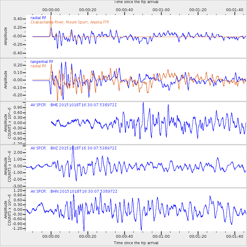
SPCR Ckakachatna River, Mount Spurr, Alaska - Earthquake Result Viewer
*The percent match for this event was below the threshold and hence no stack was calculated.
| Earthquake location: |
Tonga Islands |
| Earthquake latitude/longitude: |
-16.3/-173.2 |
| Earthquake time(UTC): |
2015/10/18 (291) 16:18:35 GMT |
| Earthquake Depth: |
10 km |
| Earthquake Magnitude: |
5.9 MWB |
| Earthquake Catalog/Contributor: |
NEIC PDE/NEIC COMCAT |
|
| Network: |
AV Alaska Volcano Observatory |
| Station: |
SPCR Ckakachatna River, Mount Spurr, Alaska |
| Lat/Lon: |
61.20 N/152.21 W |
| Elevation: |
984 m |
|
| Distance: |
79.0 deg |
| Az: |
10.171 deg |
| Baz: |
200.505 deg |
| Ray Param: |
$rayparam |
*The percent match for this event was below the threshold and hence was not used in the summary stack. |
|
| Radial Match: |
72.39212 % |
| Radial Bump: |
400 |
| Transverse Match: |
75.26285 % |
| Transverse Bump: |
400 |
| SOD ConfigId: |
7422571 |
| Insert Time: |
2019-04-21 03:34:46.775 +0000 |
| GWidth: |
2.5 |
| Max Bumps: |
400 |
| Tol: |
0.001 |
|
Signal To Noise
| Channel | StoN | STA | LTA |
| AV:SPCR: :BHZ:20151018T16:30:07.538972Z | 3.7335505 | 4.7150021E-7 | 1.2628736E-7 |
| AV:SPCR: :BHN:20151018T16:30:07.538972Z | 0.9009934 | 1.803781E-7 | 2.0019912E-7 |
| AV:SPCR: :BHE:20151018T16:30:07.538972Z | 1.1834025 | 1.6044542E-7 | 1.3557975E-7 |
| Arrivals |
| Ps | |
| PpPs | |
| PsPs/PpSs | |


