You are here: Home > Network List > AZ - ANZA Regional Network Stations List
> Station SMER AZ.SMER > Earthquake Result Viewer
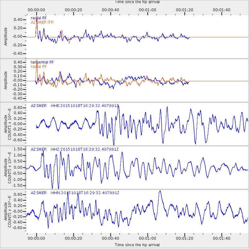
SMER AZ.SMER - Earthquake Result Viewer
*The percent match for this event was below the threshold and hence no stack was calculated.
| Earthquake location: |
Tonga Islands |
| Earthquake latitude/longitude: |
-16.3/-173.2 |
| Earthquake time(UTC): |
2015/10/18 (291) 16:18:35 GMT |
| Earthquake Depth: |
10 km |
| Earthquake Magnitude: |
5.9 MWB |
| Earthquake Catalog/Contributor: |
NEIC PDE/NEIC COMCAT |
|
| Network: |
AZ ANZA Regional Network |
| Station: |
SMER AZ.SMER |
| Lat/Lon: |
33.46 N/117.17 W |
| Elevation: |
355 m |
|
| Distance: |
72.8 deg |
| Az: |
46.532 deg |
| Baz: |
236.499 deg |
| Ray Param: |
$rayparam |
*The percent match for this event was below the threshold and hence was not used in the summary stack. |
|
| Radial Match: |
64.10594 % |
| Radial Bump: |
400 |
| Transverse Match: |
49.252304 % |
| Transverse Bump: |
400 |
| SOD ConfigId: |
7422571 |
| Insert Time: |
2019-04-21 03:34:56.920 +0000 |
| GWidth: |
2.5 |
| Max Bumps: |
400 |
| Tol: |
0.001 |
|
Signal To Noise
| Channel | StoN | STA | LTA |
| AZ:SMER: :HHZ:20151018T16:29:32.407991Z | 6.7832646 | 6.070589E-7 | 8.949362E-8 |
| AZ:SMER: :HHN:20151018T16:29:32.407991Z | 1.0315942 | 2.1816192E-7 | 2.1148036E-7 |
| AZ:SMER: :HHE:20151018T16:29:32.407991Z | 2.1301546 | 2.473696E-7 | 1.1612754E-7 |
| Arrivals |
| Ps | |
| PpPs | |
| PsPs/PpSs | |


