You are here: Home > Network List > CI - Caltech Regional Seismic Network Stations List
> Station GLA Glamis, Glamis, CA, USA > Earthquake Result Viewer
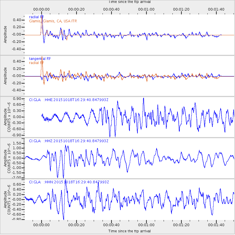
GLA Glamis, Glamis, CA, USA - Earthquake Result Viewer
*The percent match for this event was below the threshold and hence no stack was calculated.
| Earthquake location: |
Tonga Islands |
| Earthquake latitude/longitude: |
-16.3/-173.2 |
| Earthquake time(UTC): |
2015/10/18 (291) 16:18:35 GMT |
| Earthquake Depth: |
10 km |
| Earthquake Magnitude: |
5.9 MWB |
| Earthquake Catalog/Contributor: |
NEIC PDE/NEIC COMCAT |
|
| Network: |
CI Caltech Regional Seismic Network |
| Station: |
GLA Glamis, Glamis, CA, USA |
| Lat/Lon: |
33.05 N/114.83 W |
| Elevation: |
610 m |
|
| Distance: |
74.2 deg |
| Az: |
47.993 deg |
| Baz: |
238.193 deg |
| Ray Param: |
$rayparam |
*The percent match for this event was below the threshold and hence was not used in the summary stack. |
|
| Radial Match: |
78.88268 % |
| Radial Bump: |
400 |
| Transverse Match: |
59.424957 % |
| Transverse Bump: |
400 |
| SOD ConfigId: |
7422571 |
| Insert Time: |
2019-04-21 03:35:56.441 +0000 |
| GWidth: |
2.5 |
| Max Bumps: |
400 |
| Tol: |
0.001 |
|
Signal To Noise
| Channel | StoN | STA | LTA |
| CI:GLA: :HHZ:20151018T16:29:40.847993Z | 2.4291644 | 3.78346E-7 | 1.557515E-7 |
| CI:GLA: :HHN:20151018T16:29:40.847993Z | 1.5626535 | 1.3762784E-7 | 8.807316E-8 |
| CI:GLA: :HHE:20151018T16:29:40.847993Z | 2.1203847 | 2.729967E-7 | 1.2874865E-7 |
| Arrivals |
| Ps | |
| PpPs | |
| PsPs/PpSs | |


