You are here: Home > Network List > CI - Caltech Regional Seismic Network Stations List
> Station SLA SLA, Trona, CA, USA > Earthquake Result Viewer
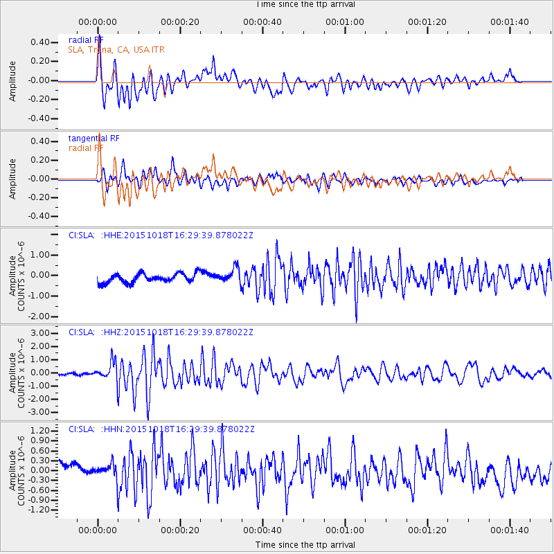
SLA SLA, Trona, CA, USA - Earthquake Result Viewer
*The percent match for this event was below the threshold and hence no stack was calculated.
| Earthquake location: |
Tonga Islands |
| Earthquake latitude/longitude: |
-16.3/-173.2 |
| Earthquake time(UTC): |
2015/10/18 (291) 16:18:35 GMT |
| Earthquake Depth: |
10 km |
| Earthquake Magnitude: |
5.9 MWB |
| Earthquake Catalog/Contributor: |
NEIC PDE/NEIC COMCAT |
|
| Network: |
CI Caltech Regional Seismic Network |
| Station: |
SLA SLA, Trona, CA, USA |
| Lat/Lon: |
35.89 N/117.28 W |
| Elevation: |
1174 m |
|
| Distance: |
74.0 deg |
| Az: |
44.374 deg |
| Baz: |
235.819 deg |
| Ray Param: |
$rayparam |
*The percent match for this event was below the threshold and hence was not used in the summary stack. |
|
| Radial Match: |
70.078094 % |
| Radial Bump: |
400 |
| Transverse Match: |
72.21437 % |
| Transverse Bump: |
400 |
| SOD ConfigId: |
7422571 |
| Insert Time: |
2019-04-21 03:36:16.438 +0000 |
| GWidth: |
2.5 |
| Max Bumps: |
400 |
| Tol: |
0.001 |
|
Signal To Noise
| Channel | StoN | STA | LTA |
| CI:SLA: :HHZ:20151018T16:29:39.878022Z | 8.299479 | 7.4557636E-7 | 8.9834124E-8 |
| CI:SLA: :HHN:20151018T16:29:39.878022Z | 1.1706699 | 2.834037E-7 | 2.4208674E-7 |
| CI:SLA: :HHE:20151018T16:29:39.878022Z | 1.6630155 | 3.633682E-7 | 2.1849958E-7 |
| Arrivals |
| Ps | |
| PpPs | |
| PsPs/PpSs | |


