You are here: Home > Network List > TA - USArray Transportable Network (new EarthScope stations) Stations List
> Station A04D Lummi Island, WA, USA > Earthquake Result Viewer
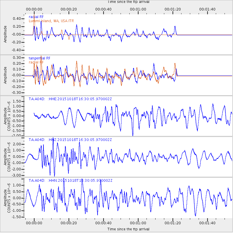
A04D Lummi Island, WA, USA - Earthquake Result Viewer
*The percent match for this event was below the threshold and hence no stack was calculated.
| Earthquake location: |
Tonga Islands |
| Earthquake latitude/longitude: |
-16.3/-173.2 |
| Earthquake time(UTC): |
2015/10/18 (291) 16:18:35 GMT |
| Earthquake Depth: |
10 km |
| Earthquake Magnitude: |
5.9 MWB |
| Earthquake Catalog/Contributor: |
NEIC PDE/NEIC COMCAT |
|
| Network: |
TA USArray Transportable Network (new EarthScope stations) |
| Station: |
A04D Lummi Island, WA, USA |
| Lat/Lon: |
48.72 N/122.71 W |
| Elevation: |
13 m |
|
| Distance: |
78.7 deg |
| Az: |
31.398 deg |
| Baz: |
229.082 deg |
| Ray Param: |
$rayparam |
*The percent match for this event was below the threshold and hence was not used in the summary stack. |
|
| Radial Match: |
65.90803 % |
| Radial Bump: |
371 |
| Transverse Match: |
46.1843 % |
| Transverse Bump: |
400 |
| SOD ConfigId: |
7422571 |
| Insert Time: |
2019-04-21 03:39:24.447 +0000 |
| GWidth: |
2.5 |
| Max Bumps: |
400 |
| Tol: |
0.001 |
|
Signal To Noise
| Channel | StoN | STA | LTA |
| TA:A04D: :HHZ:20151018T16:30:05.970002Z | 1.7327905 | 7.970659E-7 | 4.599898E-7 |
| TA:A04D: :HHN:20151018T16:30:05.970002Z | 1.3948035 | 5.7177886E-7 | 4.0993504E-7 |
| TA:A04D: :HHE:20151018T16:30:05.970002Z | 0.69141084 | 2.8090398E-7 | 4.062765E-7 |
| Arrivals |
| Ps | |
| PpPs | |
| PsPs/PpSs | |


