You are here: Home > Network List > TA - USArray Transportable Network (new EarthScope stations) Stations List
> Station J25K Salcha River, AK, USA > Earthquake Result Viewer
J25K Salcha River, AK, USA - Earthquake Result Viewer
| Earthquake location: |
Tonga Islands |
| Earthquake latitude/longitude: |
-16.3/-173.2 |
| Earthquake time(UTC): |
2015/10/18 (291) 16:18:35 GMT |
| Earthquake Depth: |
10 km |
| Earthquake Magnitude: |
5.9 MWB |
| Earthquake Catalog/Contributor: |
NEIC PDE/NEIC COMCAT |
|
| Network: |
TA USArray Transportable Network (new EarthScope stations) |
| Station: |
J25K Salcha River, AK, USA |
| Lat/Lon: |
64.61 N/145.37 W |
| Elevation: |
949 m |
|
| Distance: |
83.4 deg |
| Az: |
11.683 deg |
| Baz: |
206.821 deg |
| Ray Param: |
0.046227224 |
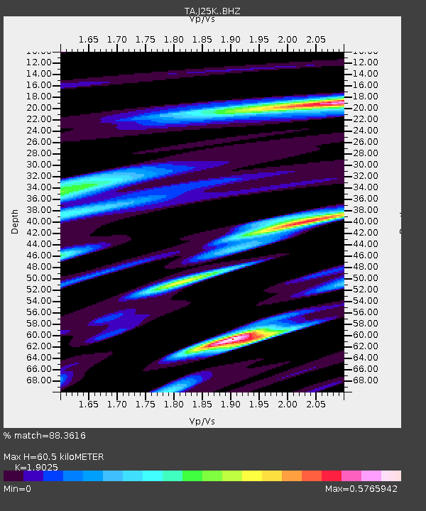
| Estimated Moho Depth: |
60.5 km |
| Estimated Crust Vp/Vs: |
1.90 |
| Assumed Crust Vp: |
6.566 km/s |
| Estimated Crust Vs: |
3.451 km/s |
| Estimated Crust Poisson's Ratio: |
0.31 |
|
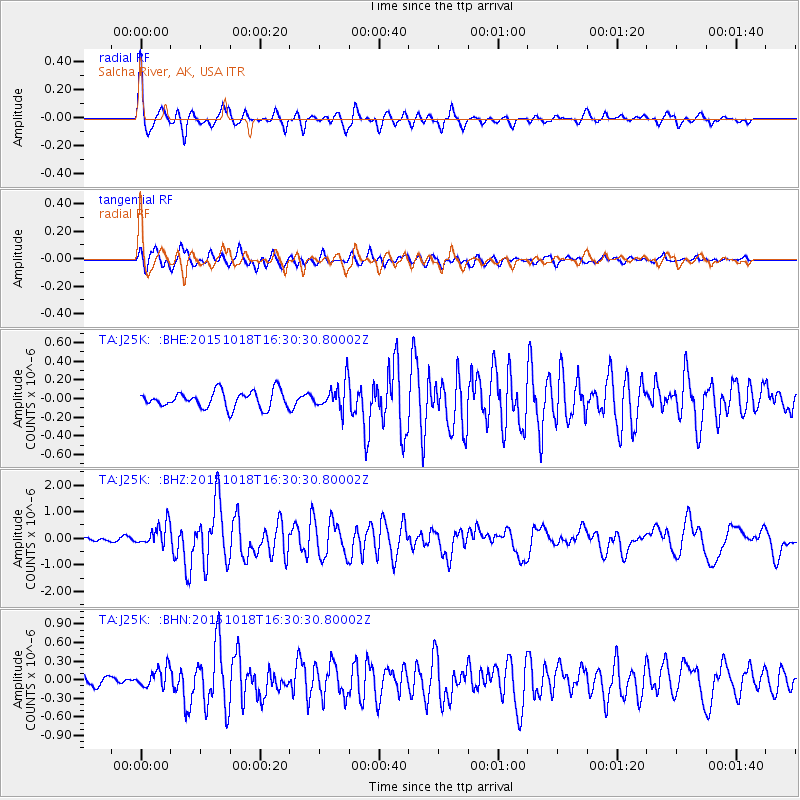
| Radial Match: |
88.3616 % |
| Radial Bump: |
400 |
| Transverse Match: |
77.88481 % |
| Transverse Bump: |
400 |
| SOD ConfigId: |
7422571 |
| Insert Time: |
2019-04-21 03:39:44.313 +0000 |
| GWidth: |
2.5 |
| Max Bumps: |
400 |
| Tol: |
0.001 |
|
Signal To Noise
| Channel | StoN | STA | LTA |
| TA:J25K: :BHZ:20151018T16:30:30.80002Z | 4.5000734 | 4.2615594E-7 | 9.469977E-8 |
| TA:J25K: :BHN:20151018T16:30:30.80002Z | 2.0309224 | 1.5859433E-7 | 7.80898E-8 |
| TA:J25K: :BHE:20151018T16:30:30.80002Z | 1.6847619 | 1.4984775E-7 | 8.894298E-8 |
| Arrivals |
| Ps | 8.5 SECOND |
| PpPs | 26 SECOND |
| PsPs/PpSs | 35 SECOND |


