You are here: Home > Network List > TA - USArray Transportable Network (new EarthScope stations) Stations List
> Station O18K Koktuh Hills, AK, USA > Earthquake Result Viewer
O18K Koktuh Hills, AK, USA - Earthquake Result Viewer
| Earthquake location: |
Tonga Islands |
| Earthquake latitude/longitude: |
-16.3/-173.2 |
| Earthquake time(UTC): |
2015/10/18 (291) 16:18:35 GMT |
| Earthquake Depth: |
10 km |
| Earthquake Magnitude: |
5.9 MWB |
| Earthquake Catalog/Contributor: |
NEIC PDE/NEIC COMCAT |
|
| Network: |
TA USArray Transportable Network (new EarthScope stations) |
| Station: |
O18K Koktuh Hills, AK, USA |
| Lat/Lon: |
59.85 N/155.21 W |
| Elevation: |
544 m |
|
| Distance: |
77.2 deg |
| Az: |
9.191 deg |
| Baz: |
197.696 deg |
| Ray Param: |
0.05046164 |
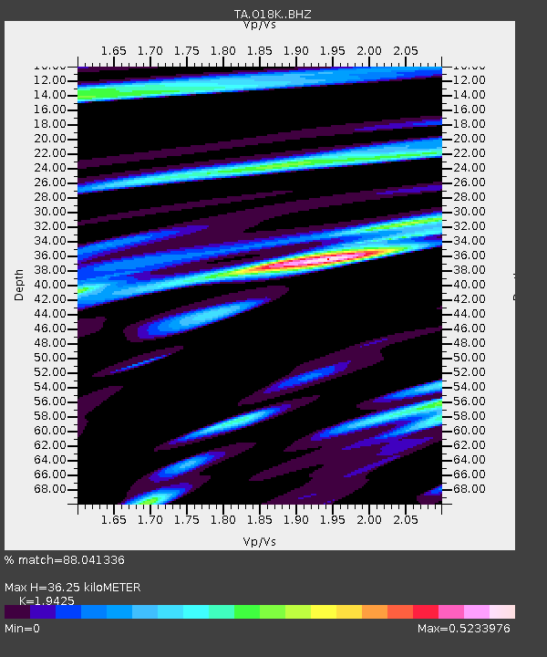
| Estimated Moho Depth: |
36.25 km |
| Estimated Crust Vp/Vs: |
1.94 |
| Assumed Crust Vp: |
6.438 km/s |
| Estimated Crust Vs: |
3.314 km/s |
| Estimated Crust Poisson's Ratio: |
0.32 |
|
| Radial Match: |
88.041336 % |
| Radial Bump: |
400 |
| Transverse Match: |
76.773186 % |
| Transverse Bump: |
400 |
| SOD ConfigId: |
7422571 |
| Insert Time: |
2019-04-21 03:40:03.901 +0000 |
| GWidth: |
2.5 |
| Max Bumps: |
400 |
| Tol: |
0.001 |
|

Signal To Noise
| Channel | StoN | STA | LTA |
| TA:O18K: :BHZ:20151018T16:29:57.80002Z | 3.4606283 | 5.3582716E-7 | 1.5483522E-7 |
| TA:O18K: :BHN:20151018T16:29:57.80002Z | 1.7749635 | 2.2709177E-7 | 1.2794166E-7 |
| TA:O18K: :BHE:20151018T16:29:57.80002Z | 1.2293367 | 1.5541417E-7 | 1.2642116E-7 |
| Arrivals |
| Ps | 5.5 SECOND |
| PpPs | 16 SECOND |
| PsPs/PpSs | 22 SECOND |


