You are here: Home > Network List > TA - USArray Transportable Network (new EarthScope stations) Stations List
> Station TCOL CIGO, UAF Yankovich Road, Fairbanks, AK, USA > Earthquake Result Viewer
TCOL CIGO, UAF Yankovich Road, Fairbanks, AK, USA - Earthquake Result Viewer
| Earthquake location: |
Tonga Islands |
| Earthquake latitude/longitude: |
-16.3/-173.2 |
| Earthquake time(UTC): |
2015/10/18 (291) 16:18:35 GMT |
| Earthquake Depth: |
10 km |
| Earthquake Magnitude: |
5.9 MWB |
| Earthquake Catalog/Contributor: |
NEIC PDE/NEIC COMCAT |
|
| Network: |
TA USArray Transportable Network (new EarthScope stations) |
| Station: |
TCOL CIGO, UAF Yankovich Road, Fairbanks, AK, USA |
| Lat/Lon: |
64.87 N/147.86 W |
| Elevation: |
178 m |
|
| Distance: |
83.2 deg |
| Az: |
10.599 deg |
| Baz: |
204.443 deg |
| Ray Param: |
0.046387732 |
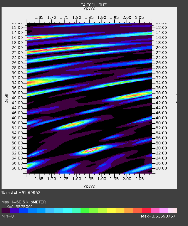
| Estimated Moho Depth: |
60.5 km |
| Estimated Crust Vp/Vs: |
1.86 |
| Assumed Crust Vp: |
6.566 km/s |
| Estimated Crust Vs: |
3.535 km/s |
| Estimated Crust Poisson's Ratio: |
0.30 |
|
| Radial Match: |
91.60953 % |
| Radial Bump: |
400 |
| Transverse Match: |
82.28652 % |
| Transverse Bump: |
400 |
| SOD ConfigId: |
7422571 |
| Insert Time: |
2019-04-21 03:40:15.304 +0000 |
| GWidth: |
2.5 |
| Max Bumps: |
400 |
| Tol: |
0.001 |
|

Signal To Noise
| Channel | StoN | STA | LTA |
| TA:TCOL: :BHZ:20151018T16:30:29.649995Z | 6.375952 | 5.8119895E-7 | 9.115485E-8 |
| TA:TCOL: :BHN:20151018T16:30:29.649995Z | 5.564036 | 4.4130914E-7 | 7.9314574E-8 |
| TA:TCOL: :BHE:20151018T16:30:29.649995Z | 2.2159107 | 2.3047373E-7 | 1.0400858E-7 |
| Arrivals |
| Ps | 8.1 SECOND |
| PpPs | 26 SECOND |
| PsPs/PpSs | 34 SECOND |


