You are here: Home > Network List > TA - USArray Transportable Network (new EarthScope stations) Stations List
> Station TPFO Pinon Flats, CA, USA > Earthquake Result Viewer
TPFO Pinon Flats, CA, USA - Earthquake Result Viewer
| Earthquake location: |
Tonga Islands |
| Earthquake latitude/longitude: |
-16.3/-173.2 |
| Earthquake time(UTC): |
2015/10/18 (291) 16:18:35 GMT |
| Earthquake Depth: |
10 km |
| Earthquake Magnitude: |
5.9 MWB |
| Earthquake Catalog/Contributor: |
NEIC PDE/NEIC COMCAT |
|
| Network: |
TA USArray Transportable Network (new EarthScope stations) |
| Station: |
TPFO Pinon Flats, CA, USA |
| Lat/Lon: |
33.61 N/116.45 W |
| Elevation: |
1275 m |
|
| Distance: |
73.4 deg |
| Az: |
46.746 deg |
| Baz: |
236.955 deg |
| Ray Param: |
0.053061813 |
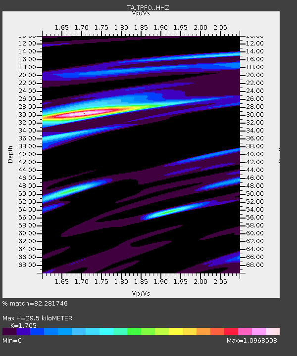
| Estimated Moho Depth: |
29.5 km |
| Estimated Crust Vp/Vs: |
1.71 |
| Assumed Crust Vp: |
6.264 km/s |
| Estimated Crust Vs: |
3.674 km/s |
| Estimated Crust Poisson's Ratio: |
0.24 |
|
| Radial Match: |
82.281746 % |
| Radial Bump: |
400 |
| Transverse Match: |
73.890816 % |
| Transverse Bump: |
364 |
| SOD ConfigId: |
7422571 |
| Insert Time: |
2019-04-21 03:40:17.197 +0000 |
| GWidth: |
2.5 |
| Max Bumps: |
400 |
| Tol: |
0.001 |
|
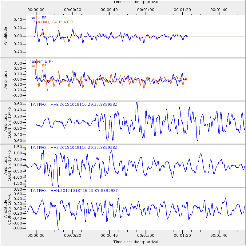
Signal To Noise
| Channel | StoN | STA | LTA |
| TA:TPFO: :HHZ:20151018T16:29:35.839998Z | 4.6919084 | 5.53456E-7 | 1.1795968E-7 |
| TA:TPFO: :HHN:20151018T16:29:35.839998Z | 1.3848808 | 2.1380716E-7 | 1.5438668E-7 |
| TA:TPFO: :HHE:20151018T16:29:35.839998Z | 1.690089 | 1.4110461E-7 | 8.3489454E-8 |
| Arrivals |
| Ps | 3.4 SECOND |
| PpPs | 12 SECOND |
| PsPs/PpSs | 16 SECOND |


