You are here: Home > Network List > UW - Pacific Northwest Regional Seismic Network Stations List
> Station LCCR Mulino, OR, USA > Earthquake Result Viewer
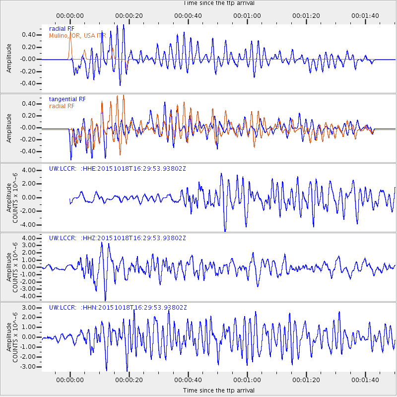
LCCR Mulino, OR, USA - Earthquake Result Viewer
*The percent match for this event was below the threshold and hence no stack was calculated.
| Earthquake location: |
Tonga Islands |
| Earthquake latitude/longitude: |
-16.3/-173.2 |
| Earthquake time(UTC): |
2015/10/18 (291) 16:18:35 GMT |
| Earthquake Depth: |
10 km |
| Earthquake Magnitude: |
5.9 MWB |
| Earthquake Catalog/Contributor: |
NEIC PDE/NEIC COMCAT |
|
| Network: |
UW Pacific Northwest Regional Seismic Network |
| Station: |
LCCR Mulino, OR, USA |
| Lat/Lon: |
45.21 N/122.48 W |
| Elevation: |
273 m |
|
| Distance: |
76.5 deg |
| Az: |
34.238 deg |
| Baz: |
229.859 deg |
| Ray Param: |
$rayparam |
*The percent match for this event was below the threshold and hence was not used in the summary stack. |
|
| Radial Match: |
69.996925 % |
| Radial Bump: |
400 |
| Transverse Match: |
71.26556 % |
| Transverse Bump: |
400 |
| SOD ConfigId: |
7422571 |
| Insert Time: |
2019-04-21 03:40:58.596 +0000 |
| GWidth: |
2.5 |
| Max Bumps: |
400 |
| Tol: |
0.001 |
|
Signal To Noise
| Channel | StoN | STA | LTA |
| UW:LCCR: :HHZ:20151018T16:29:53.93802Z | 1.4989308 | 5.6480195E-7 | 3.7680323E-7 |
| UW:LCCR: :HHN:20151018T16:29:53.93802Z | 1.3644347 | 4.0511136E-7 | 2.9690784E-7 |
| UW:LCCR: :HHE:20151018T16:29:53.93802Z | 0.9490614 | 3.8450702E-7 | 4.051445E-7 |
| Arrivals |
| Ps | |
| PpPs | |
| PsPs/PpSs | |


