You are here: Home > Network List > UW - Pacific Northwest Regional Seismic Network Stations List
> Station OMAK Colville Reservation, Omak, WA, USA > Earthquake Result Viewer
OMAK Colville Reservation, Omak, WA, USA - Earthquake Result Viewer
*The percent match for this event was below the threshold and hence no stack was calculated.
| Earthquake location: |
Tonga Islands |
| Earthquake latitude/longitude: |
-16.3/-173.2 |
| Earthquake time(UTC): |
2015/10/18 (291) 16:18:35 GMT |
| Earthquake Depth: |
10 km |
| Earthquake Magnitude: |
5.9 MWB |
| Earthquake Catalog/Contributor: |
NEIC PDE/NEIC COMCAT |
|
| Network: |
UW Pacific Northwest Regional Seismic Network |
| Station: |
OMAK Colville Reservation, Omak, WA, USA |
| Lat/Lon: |
48.36 N/119.33 W |
| Elevation: |
696 m |
|
| Distance: |
80.2 deg |
| Az: |
33.133 deg |
| Baz: |
231.921 deg |
| Ray Param: |
$rayparam |
*The percent match for this event was below the threshold and hence was not used in the summary stack. |
|
| Radial Match: |
75.23493 % |
| Radial Bump: |
325 |
| Transverse Match: |
67.07565 % |
| Transverse Bump: |
400 |
| SOD ConfigId: |
7422571 |
| Insert Time: |
2019-04-21 03:41:02.684 +0000 |
| GWidth: |
2.5 |
| Max Bumps: |
400 |
| Tol: |
0.001 |
|
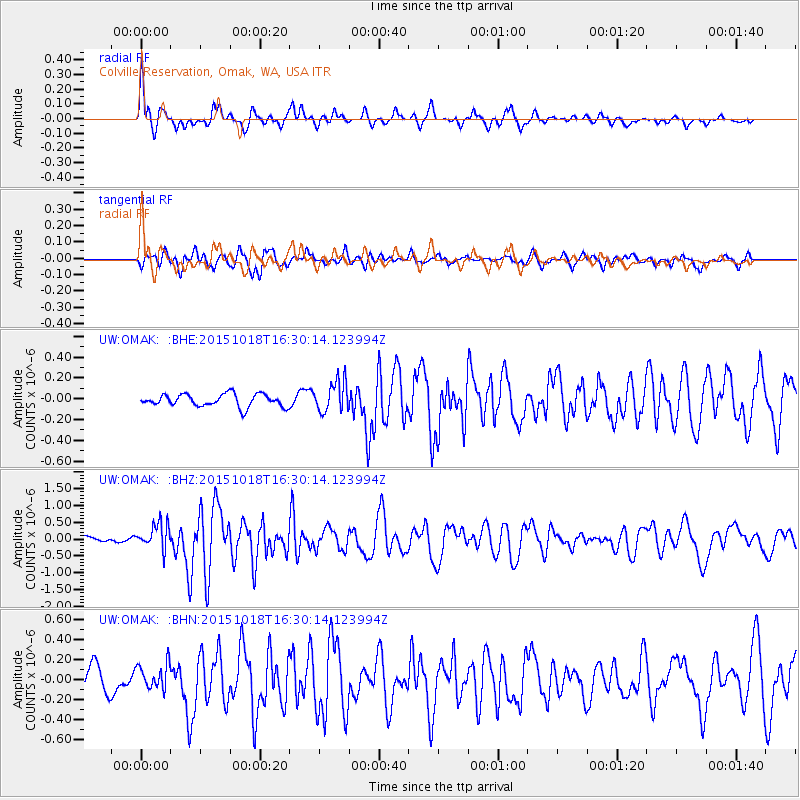
Signal To Noise
| Channel | StoN | STA | LTA |
| UW:OMAK: :BHZ:20151018T16:30:14.123994Z | 3.7208948 | 3.8446905E-7 | 1.0332704E-7 |
| UW:OMAK: :BHN:20151018T16:30:14.123994Z | 0.8272863 | 1.2913992E-7 | 1.5610063E-7 |
| UW:OMAK: :BHE:20151018T16:30:14.123994Z | 2.4660213 | 1.4695166E-7 | 5.9590594E-8 |
| Arrivals |
| Ps | |
| PpPs | |
| PsPs/PpSs | |


