You are here: Home > Network List > XD14 - Illuminating the architecture of the greater Mount St. Helens magmatic systems f Stations List
> Station MP06 "Mount St Helens, WA" > Earthquake Result Viewer
MP06 "Mount St Helens, WA" - Earthquake Result Viewer
| Earthquake location: |
Tonga Islands |
| Earthquake latitude/longitude: |
-16.3/-173.2 |
| Earthquake time(UTC): |
2015/10/18 (291) 16:18:35 GMT |
| Earthquake Depth: |
10 km |
| Earthquake Magnitude: |
5.9 MWB |
| Earthquake Catalog/Contributor: |
NEIC PDE/NEIC COMCAT |
|
| Network: |
XD Illuminating the architecture of the greater Mount St. Helens magmatic systems f |
| Station: |
MP06 "Mount St Helens, WA" |
| Lat/Lon: |
45.83 N/122.20 W |
| Elevation: |
796 m |
|
| Distance: |
77.1 deg |
| Az: |
33.878 deg |
| Baz: |
229.977 deg |
| Ray Param: |
0.05057402 |
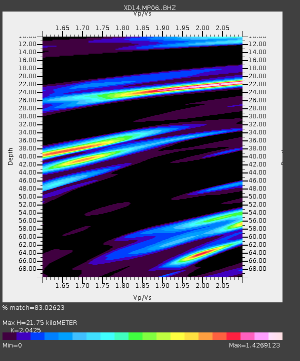
| Estimated Moho Depth: |
21.75 km |
| Estimated Crust Vp/Vs: |
2.04 |
| Assumed Crust Vp: |
6.566 km/s |
| Estimated Crust Vs: |
3.215 km/s |
| Estimated Crust Poisson's Ratio: |
0.34 |
|
| Radial Match: |
83.02623 % |
| Radial Bump: |
400 |
| Transverse Match: |
61.496277 % |
| Transverse Bump: |
400 |
| SOD ConfigId: |
7422571 |
| Insert Time: |
2019-04-21 03:41:59.508 +0000 |
| GWidth: |
2.5 |
| Max Bumps: |
400 |
| Tol: |
0.001 |
|

Signal To Noise
| Channel | StoN | STA | LTA |
| XD:MP06: :BHZ:20151018T16:29:57.064973Z | 3.449082 | 5.7863014E-7 | 1.6776352E-7 |
| XD:MP06: :BHN:20151018T16:29:57.064973Z | 1.3773636 | 1.4675628E-7 | 1.0654869E-7 |
| XD:MP06: :BHE:20151018T16:29:57.064973Z | 1.4865911 | 2.5785505E-7 | 1.7345391E-7 |
| Arrivals |
| Ps | 3.6 SECOND |
| PpPs | 9.8 SECOND |
| PsPs/PpSs | 13 SECOND |


