You are here: Home > Network List > YT07 - POLENET Stations List
> Station ALYS ALYS > Earthquake Result Viewer
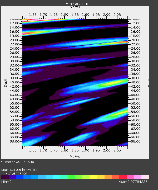
ALYS ALYS - Earthquake Result Viewer
| Earthquake location: |
Tonga Islands |
| Earthquake latitude/longitude: |
-16.3/-173.2 |
| Earthquake time(UTC): |
2015/10/18 (291) 16:18:35 GMT |
| Earthquake Depth: |
10 km |
| Earthquake Magnitude: |
5.9 MWB |
| Earthquake Catalog/Contributor: |
NEIC PDE/NEIC COMCAT |
|
| Network: |
YT POLENET |
| Station: |
ALYS ALYS |
| Lat/Lon: |
84.35 S/23.73 W |
| Elevation: |
2084 m |
|
| Distance: |
78.8 deg |
| Az: |
177.058 deg |
| Baz: |
209.852 deg |
| Ray Param: |
0.049422156 |
| Estimated Moho Depth: |
10.5 km |
| Estimated Crust Vp/Vs: |
1.62 |
| Assumed Crust Vp: |
6.356 km/s |
| Estimated Crust Vs: |
3.918 km/s |
| Estimated Crust Poisson's Ratio: |
0.19 |
|
| Radial Match: |
91.69584 % |
| Radial Bump: |
400 |
| Transverse Match: |
88.13892 % |
| Transverse Bump: |
400 |
| SOD ConfigId: |
7422571 |
| Insert Time: |
2019-04-21 03:42:25.257 +0000 |
| GWidth: |
2.5 |
| Max Bumps: |
400 |
| Tol: |
0.001 |
|

Signal To Noise
| Channel | StoN | STA | LTA |
| YT:ALYS: :BHZ:20151018T16:30:06.80002Z | 22.528936 | 3.1069433E-6 | 1.3790901E-7 |
| YT:ALYS: :BHN:20151018T16:30:06.80002Z | 6.7965183 | 5.793109E-7 | 8.523642E-8 |
| YT:ALYS: :BHE:20151018T16:30:06.80002Z | 2.9388294 | 4.1334877E-7 | 1.4065083E-7 |
| Arrivals |
| Ps | 1.1 SECOND |
| PpPs | 4.2 SECOND |
| PsPs/PpSs | 5.3 SECOND |


