You are here: Home > Network List > YT07 - POLENET Stations List
> Station THUR THUR > Earthquake Result Viewer
THUR THUR - Earthquake Result Viewer
| Earthquake location: |
Tonga Islands |
| Earthquake latitude/longitude: |
-16.3/-173.2 |
| Earthquake time(UTC): |
2015/10/18 (291) 16:18:35 GMT |
| Earthquake Depth: |
10 km |
| Earthquake Magnitude: |
5.9 MWB |
| Earthquake Catalog/Contributor: |
NEIC PDE/NEIC COMCAT |
|
| Network: |
YT POLENET |
| Station: |
THUR THUR |
| Lat/Lon: |
72.53 S/97.56 W |
| Elevation: |
239 m |
|
| Distance: |
70.3 deg |
| Az: |
161.893 deg |
| Baz: |
278.756 deg |
| Ray Param: |
0.055079356 |
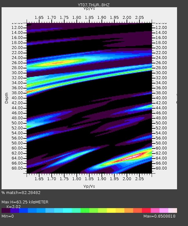
| Estimated Moho Depth: |
63.25 km |
| Estimated Crust Vp/Vs: |
2.02 |
| Assumed Crust Vp: |
6.43 km/s |
| Estimated Crust Vs: |
3.183 km/s |
| Estimated Crust Poisson's Ratio: |
0.34 |
|
| Radial Match: |
82.28482 % |
| Radial Bump: |
382 |
| Transverse Match: |
78.49965 % |
| Transverse Bump: |
400 |
| SOD ConfigId: |
7422571 |
| Insert Time: |
2019-04-21 03:42:49.516 +0000 |
| GWidth: |
2.5 |
| Max Bumps: |
400 |
| Tol: |
0.001 |
|

Signal To Noise
| Channel | StoN | STA | LTA |
| YT:THUR: :BHZ:20151018T16:29:17.874971Z | 9.7893915 | 1.5279189E-6 | 1.5607905E-7 |
| YT:THUR: :BHN:20151018T16:29:17.874971Z | 0.7914012 | 1.6354812E-7 | 2.0665641E-7 |
| YT:THUR: :BHE:20151018T16:29:17.874971Z | 2.4350307 | 6.5343914E-7 | 2.6834945E-7 |
| Arrivals |
| Ps | 10 SECOND |
| PpPs | 29 SECOND |
| PsPs/PpSs | 39 SECOND |


