You are here: Home > Network List > YT07 - POLENET Stations List
> Station WHIT WHIT > Earthquake Result Viewer
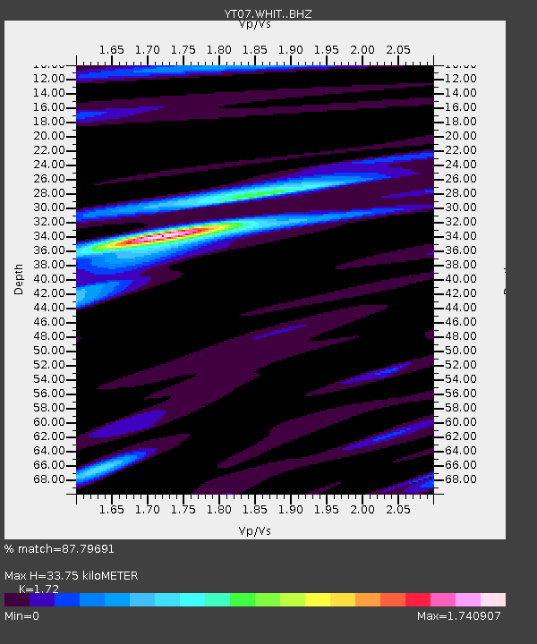
WHIT WHIT - Earthquake Result Viewer
| Earthquake location: |
Tonga Islands |
| Earthquake latitude/longitude: |
-16.3/-173.2 |
| Earthquake time(UTC): |
2015/10/18 (291) 16:18:35 GMT |
| Earthquake Depth: |
10 km |
| Earthquake Magnitude: |
5.9 MWB |
| Earthquake Catalog/Contributor: |
NEIC PDE/NEIC COMCAT |
|
| Network: |
YT POLENET |
| Station: |
WHIT WHIT |
| Lat/Lon: |
82.68 S/104.39 W |
| Elevation: |
2343 m |
|
| Distance: |
71.3 deg |
| Az: |
172.75 deg |
| Baz: |
289.028 deg |
| Ray Param: |
0.05441278 |
| Estimated Moho Depth: |
33.75 km |
| Estimated Crust Vp/Vs: |
1.72 |
| Assumed Crust Vp: |
6.356 km/s |
| Estimated Crust Vs: |
3.695 km/s |
| Estimated Crust Poisson's Ratio: |
0.24 |
|
| Radial Match: |
87.79691 % |
| Radial Bump: |
324 |
| Transverse Match: |
65.44256 % |
| Transverse Bump: |
400 |
| SOD ConfigId: |
7422571 |
| Insert Time: |
2019-04-21 03:42:53.294 +0000 |
| GWidth: |
2.5 |
| Max Bumps: |
400 |
| Tol: |
0.001 |
|

Signal To Noise
| Channel | StoN | STA | LTA |
| YT:WHIT: :BHZ:20151018T16:29:23.97397Z | 9.153475 | 1.2976901E-6 | 1.4177022E-7 |
| YT:WHIT: :BHN:20151018T16:29:23.97397Z | 3.8701208 | 2.5183996E-7 | 6.5072896E-8 |
| YT:WHIT: :BHE:20151018T16:29:23.97397Z | 4.212632 | 5.100532E-7 | 1.2107706E-7 |
| Arrivals |
| Ps | 4.0 SECOND |
| PpPs | 14 SECOND |
| PsPs/PpSs | 18 SECOND |


