You are here: Home > Network List > ZJ12 - Transantarctic Mountains Northern Network Stations List
> Station RAPH Exposure Hill, Antarctica > Earthquake Result Viewer
RAPH Exposure Hill, Antarctica - Earthquake Result Viewer
| Earthquake location: |
Tonga Islands |
| Earthquake latitude/longitude: |
-16.3/-173.2 |
| Earthquake time(UTC): |
2015/10/18 (291) 16:18:35 GMT |
| Earthquake Depth: |
10 km |
| Earthquake Magnitude: |
5.9 MWB |
| Earthquake Catalog/Contributor: |
NEIC PDE/NEIC COMCAT |
|
| Network: |
ZJ Transantarctic Mountains Northern Network |
| Station: |
RAPH Exposure Hill, Antarctica |
| Lat/Lon: |
73.60 S/162.29 E |
| Elevation: |
3052 m |
|
| Distance: |
59.0 deg |
| Az: |
187.909 deg |
| Baz: |
27.721 deg |
| Ray Param: |
0.06247678 |
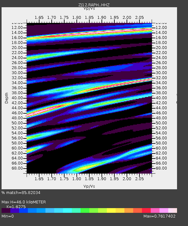
| Estimated Moho Depth: |
46.0 km |
| Estimated Crust Vp/Vs: |
1.63 |
| Assumed Crust Vp: |
6.264 km/s |
| Estimated Crust Vs: |
3.849 km/s |
| Estimated Crust Poisson's Ratio: |
0.20 |
|
| Radial Match: |
85.82034 % |
| Radial Bump: |
387 |
| Transverse Match: |
72.43637 % |
| Transverse Bump: |
400 |
| SOD ConfigId: |
7422571 |
| Insert Time: |
2019-04-21 03:43:04.495 +0000 |
| GWidth: |
2.5 |
| Max Bumps: |
400 |
| Tol: |
0.001 |
|

Signal To Noise
| Channel | StoN | STA | LTA |
| ZJ:RAPH: :HHZ:20151018T16:28:04.160005Z | 2.4902663 | 2.4756687E-7 | 9.941381E-8 |
| ZJ:RAPH: :HHN:20151018T16:28:04.160005Z | 0.8112119 | 1.0752471E-7 | 1.3254825E-7 |
| ZJ:RAPH: :HHE:20151018T16:28:04.160005Z | 1.0527402 | 7.999028E-8 | 7.5982925E-8 |
| Arrivals |
| Ps | 4.8 SECOND |
| PpPs | 18 SECOND |
| PsPs/PpSs | 23 SECOND |


