You are here: Home > Network List > ZJ12 - Transantarctic Mountains Northern Network Stations List
> Station SAMH East Antarctica > Earthquake Result Viewer
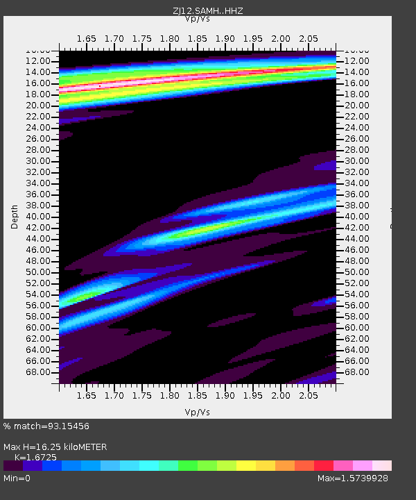
SAMH East Antarctica - Earthquake Result Viewer
| Earthquake location: |
Tonga Islands |
| Earthquake latitude/longitude: |
-16.3/-173.2 |
| Earthquake time(UTC): |
2015/10/18 (291) 16:18:35 GMT |
| Earthquake Depth: |
10 km |
| Earthquake Magnitude: |
5.9 MWB |
| Earthquake Catalog/Contributor: |
NEIC PDE/NEIC COMCAT |
|
| Network: |
ZJ Transantarctic Mountains Northern Network |
| Station: |
SAMH East Antarctica |
| Lat/Lon: |
75.20 S/154.00 E |
| Elevation: |
2087 m |
|
| Distance: |
61.6 deg |
| Az: |
189.115 deg |
| Baz: |
36.303 deg |
| Ray Param: |
0.06079805 |
| Estimated Moho Depth: |
16.25 km |
| Estimated Crust Vp/Vs: |
1.67 |
| Assumed Crust Vp: |
6.262 km/s |
| Estimated Crust Vs: |
3.744 km/s |
| Estimated Crust Poisson's Ratio: |
0.22 |
|
| Radial Match: |
93.15456 % |
| Radial Bump: |
400 |
| Transverse Match: |
83.619095 % |
| Transverse Bump: |
400 |
| SOD ConfigId: |
7422571 |
| Insert Time: |
2019-04-21 03:43:05.184 +0000 |
| GWidth: |
2.5 |
| Max Bumps: |
400 |
| Tol: |
0.001 |
|

Signal To Noise
| Channel | StoN | STA | LTA |
| ZJ:SAMH: :HHZ:20151018T16:28:21.589021Z | 20.218006 | 2.6139562E-6 | 1.2928852E-7 |
| ZJ:SAMH: :HHN:20151018T16:28:21.589021Z | 3.2287138 | 5.746703E-7 | 1.7798737E-7 |
| ZJ:SAMH: :HHE:20151018T16:28:21.589021Z | 2.1909623 | 3.3080985E-7 | 1.5098837E-7 |
| Arrivals |
| Ps | 1.8 SECOND |
| PpPs | 6.6 SECOND |
| PsPs/PpSs | 8.5 SECOND |


