You are here: Home > Network List > GS - US Geological Survey Networks Stations List
> Station DEC13 Justin Breden Machine Shed, Decatur, IL, USA > Earthquake Result Viewer
DEC13 Justin Breden Machine Shed, Decatur, IL, USA - Earthquake Result Viewer
| Earthquake location: |
Alaska Peninsula |
| Earthquake latitude/longitude: |
56.7/-156.5 |
| Earthquake time(UTC): |
2015/05/29 (149) 07:00:08 GMT |
| Earthquake Depth: |
62 km |
| Earthquake Magnitude: |
6.8 MWP, 6.8 MI |
| Earthquake Catalog/Contributor: |
NEIC PDE/NEIC COMCAT |
|
| Network: |
GS US Geological Survey Networks |
| Station: |
DEC13 Justin Breden Machine Shed, Decatur, IL, USA |
| Lat/Lon: |
39.90 N/88.88 W |
| Elevation: |
224 m |
|
| Distance: |
46.0 deg |
| Az: |
81.328 deg |
| Baz: |
314.85 deg |
| Ray Param: |
0.070722796 |
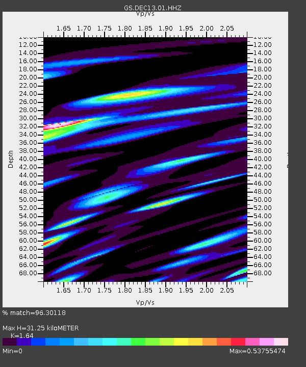
| Estimated Moho Depth: |
31.25 km |
| Estimated Crust Vp/Vs: |
1.64 |
| Assumed Crust Vp: |
6.444 km/s |
| Estimated Crust Vs: |
3.929 km/s |
| Estimated Crust Poisson's Ratio: |
0.20 |
|
| Radial Match: |
96.30118 % |
| Radial Bump: |
349 |
| Transverse Match: |
68.02342 % |
| Transverse Bump: |
400 |
| SOD ConfigId: |
976571 |
| Insert Time: |
2015-06-12 07:13:23.548 +0000 |
| GWidth: |
2.5 |
| Max Bumps: |
400 |
| Tol: |
0.001 |
|

Signal To Noise
| Channel | StoN | STA | LTA |
| GS:DEC13:01:HHZ:20150529T07:07:55.335007Z | 35.054207 | 6.3251578E-6 | 1.8043933E-7 |
| GS:DEC13:01:HHN:20150529T07:07:55.335007Z | 6.5034976 | 2.7519907E-6 | 4.2315548E-7 |
| GS:DEC13:01:HHE:20150529T07:07:55.335007Z | 4.2836146 | 2.9779799E-6 | 6.952026E-7 |
| Arrivals |
| Ps | 3.3 SECOND |
| PpPs | 12 SECOND |
| PsPs/PpSs | 15 SECOND |


