You are here: Home > Network List > GS - US Geological Survey Networks Stations List
> Station KAN01 Ward Farm, Argonia, KS, USA > Earthquake Result Viewer
KAN01 Ward Farm, Argonia, KS, USA - Earthquake Result Viewer
| Earthquake location: |
Alaska Peninsula |
| Earthquake latitude/longitude: |
56.7/-156.5 |
| Earthquake time(UTC): |
2015/05/29 (149) 07:00:08 GMT |
| Earthquake Depth: |
62 km |
| Earthquake Magnitude: |
6.8 MWP, 6.8 MI |
| Earthquake Catalog/Contributor: |
NEIC PDE/NEIC COMCAT |
|
| Network: |
GS US Geological Survey Networks |
| Station: |
KAN01 Ward Farm, Argonia, KS, USA |
| Lat/Lon: |
37.15 N/97.76 W |
| Elevation: |
360 m |
|
| Distance: |
43.1 deg |
| Az: |
91.151 deg |
| Baz: |
316.341 deg |
| Ray Param: |
0.07257967 |
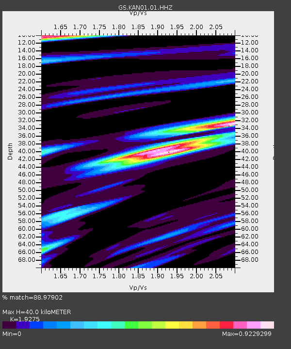
| Estimated Moho Depth: |
40.0 km |
| Estimated Crust Vp/Vs: |
1.93 |
| Assumed Crust Vp: |
6.483 km/s |
| Estimated Crust Vs: |
3.363 km/s |
| Estimated Crust Poisson's Ratio: |
0.32 |
|
| Radial Match: |
88.97902 % |
| Radial Bump: |
400 |
| Transverse Match: |
44.468353 % |
| Transverse Bump: |
400 |
| SOD ConfigId: |
976571 |
| Insert Time: |
2015-06-12 07:13:26.076 +0000 |
| GWidth: |
2.5 |
| Max Bumps: |
400 |
| Tol: |
0.001 |
|

Signal To Noise
| Channel | StoN | STA | LTA |
| GS:KAN01:01:HHZ:20150529T07:07:32.069993Z | 47.06511 | 4.942525E-6 | 1.0501462E-7 |
| GS:KAN01:01:HHN:20150529T07:07:32.069993Z | 6.3417373 | 2.2550755E-6 | 3.555927E-7 |
| GS:KAN01:01:HHE:20150529T07:07:32.069993Z | 1.6631342 | 2.2159945E-6 | 1.3324207E-6 |
| Arrivals |
| Ps | 6.1 SECOND |
| PpPs | 17 SECOND |
| PsPs/PpSs | 23 SECOND |


