You are here: Home > Network List > GS - US Geological Survey Networks Stations List
> Station KAN12 Houston Home, Harper, KS, USA > Earthquake Result Viewer
KAN12 Houston Home, Harper, KS, USA - Earthquake Result Viewer
| Earthquake location: |
Alaska Peninsula |
| Earthquake latitude/longitude: |
56.7/-156.5 |
| Earthquake time(UTC): |
2015/05/29 (149) 07:00:08 GMT |
| Earthquake Depth: |
62 km |
| Earthquake Magnitude: |
6.8 MWP, 6.8 MI |
| Earthquake Catalog/Contributor: |
NEIC PDE/NEIC COMCAT |
|
| Network: |
GS US Geological Survey Networks |
| Station: |
KAN12 Houston Home, Harper, KS, USA |
| Lat/Lon: |
37.30 N/98.00 W |
| Elevation: |
426 m |
|
| Distance: |
42.9 deg |
| Az: |
91.207 deg |
| Baz: |
316.239 deg |
| Ray Param: |
0.07273058 |
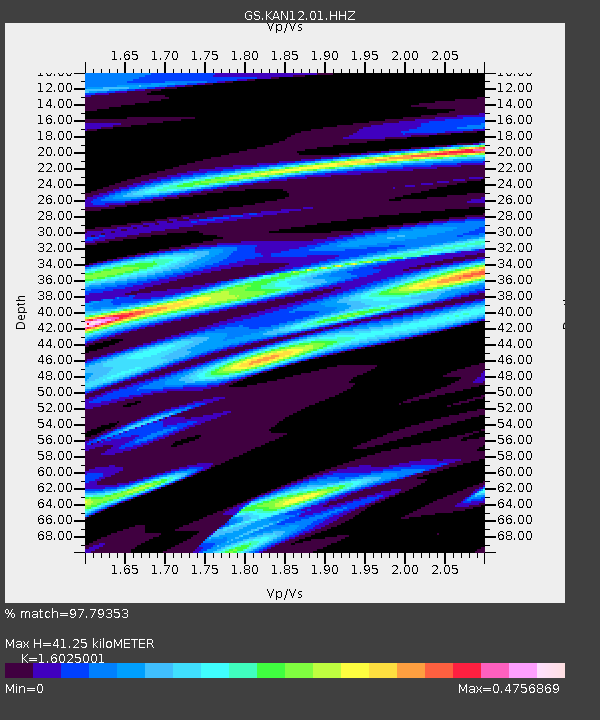
| Estimated Moho Depth: |
41.25 km |
| Estimated Crust Vp/Vs: |
1.60 |
| Assumed Crust Vp: |
6.483 km/s |
| Estimated Crust Vs: |
4.045 km/s |
| Estimated Crust Poisson's Ratio: |
0.18 |
|
| Radial Match: |
97.79353 % |
| Radial Bump: |
284 |
| Transverse Match: |
88.899376 % |
| Transverse Bump: |
400 |
| SOD ConfigId: |
976571 |
| Insert Time: |
2015-06-12 07:13:45.787 +0000 |
| GWidth: |
2.5 |
| Max Bumps: |
400 |
| Tol: |
0.001 |
|

Signal To Noise
| Channel | StoN | STA | LTA |
| GS:KAN12:01:HHZ:20150529T07:07:30.169999Z | 62.340263 | 5.2138766E-6 | 8.363578E-8 |
| GS:KAN12:01:HHN:20150529T07:07:30.169999Z | 9.032685 | 2.285091E-6 | 2.5298027E-7 |
| GS:KAN12:01:HHE:20150529T07:07:30.169999Z | 11.699121 | 2.277602E-6 | 1.9468146E-7 |
| Arrivals |
| Ps | 4.1 SECOND |
| PpPs | 15 SECOND |
| PsPs/PpSs | 19 SECOND |


