You are here: Home > Network List > KN - Kyrgyz Seismic Telemetry Network Stations List
> Station ULHL - > Earthquake Result Viewer
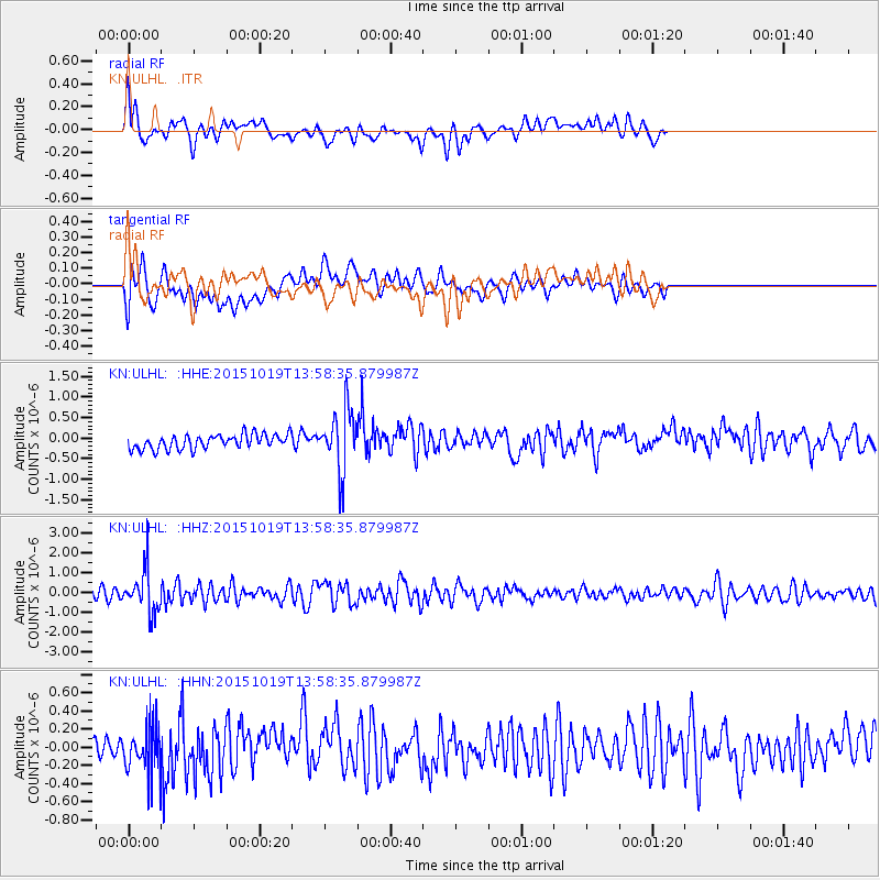
ULHL - - Earthquake Result Viewer
*The percent match for this event was below the threshold and hence no stack was calculated.
| Earthquake location: |
Mindoro, Philippines |
| Earthquake latitude/longitude: |
13.9/120.6 |
| Earthquake time(UTC): |
2015/10/19 (292) 13:50:41 GMT |
| Earthquake Depth: |
106 km |
| Earthquake Magnitude: |
5.8 MWB, 5.9 MWC |
| Earthquake Catalog/Contributor: |
NEIC PDE/NEIC COMCAT |
|
| Network: |
KN Kyrgyz Seismic Telemetry Network |
| Station: |
ULHL - |
| Lat/Lon: |
42.25 N/76.24 E |
| Elevation: |
2040 m |
|
| Distance: |
47.6 deg |
| Az: |
315.277 deg |
| Baz: |
113.003 deg |
| Ray Param: |
$rayparam |
*The percent match for this event was below the threshold and hence was not used in the summary stack. |
|
| Radial Match: |
66.70087 % |
| Radial Bump: |
400 |
| Transverse Match: |
60.30897 % |
| Transverse Bump: |
400 |
| SOD ConfigId: |
7422571 |
| Insert Time: |
2019-04-21 03:53:49.640 +0000 |
| GWidth: |
2.5 |
| Max Bumps: |
400 |
| Tol: |
0.001 |
|
Signal To Noise
| Channel | StoN | STA | LTA |
| KN:ULHL: :HHZ:20151019T13:58:35.879987Z | 4.396563 | 1.0835267E-6 | 2.464486E-7 |
| KN:ULHL: :HHN:20151019T13:58:35.879987Z | 1.2667394 | 2.533209E-7 | 1.999787E-7 |
| KN:ULHL: :HHE:20151019T13:58:35.879987Z | 4.2501383 | 7.4121914E-7 | 1.7439883E-7 |
| Arrivals |
| Ps | |
| PpPs | |
| PsPs/PpSs | |


