You are here: Home > Network List > IU - Global Seismograph Network (GSN - IRIS/USGS) Stations List
> Station PAYG Puerto Ayora, Galapagos Islands > Earthquake Result Viewer
PAYG Puerto Ayora, Galapagos Islands - Earthquake Result Viewer
| Earthquake location: |
Alaska Peninsula |
| Earthquake latitude/longitude: |
56.7/-156.5 |
| Earthquake time(UTC): |
2015/05/29 (149) 07:00:08 GMT |
| Earthquake Depth: |
62 km |
| Earthquake Magnitude: |
6.8 MWP, 6.8 MI |
| Earthquake Catalog/Contributor: |
NEIC PDE/NEIC COMCAT |
|
| Network: |
IU Global Seismograph Network (GSN - IRIS/USGS) |
| Station: |
PAYG Puerto Ayora, Galapagos Islands |
| Lat/Lon: |
0.67 S/90.29 W |
| Elevation: |
270 m |
|
| Distance: |
77.7 deg |
| Az: |
110.513 deg |
| Baz: |
328.886 deg |
| Ray Param: |
0.049998686 |
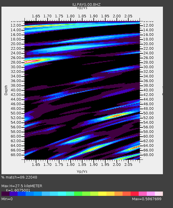
| Estimated Moho Depth: |
27.5 km |
| Estimated Crust Vp/Vs: |
1.61 |
| Assumed Crust Vp: |
4.802 km/s |
| Estimated Crust Vs: |
2.987 km/s |
| Estimated Crust Poisson's Ratio: |
0.18 |
|
| Radial Match: |
89.22048 % |
| Radial Bump: |
369 |
| Transverse Match: |
88.0602 % |
| Transverse Bump: |
400 |
| SOD ConfigId: |
976571 |
| Insert Time: |
2015-06-12 07:15:31.044 +0000 |
| GWidth: |
2.5 |
| Max Bumps: |
400 |
| Tol: |
0.001 |
|
Signal To Noise
| Channel | StoN | STA | LTA |
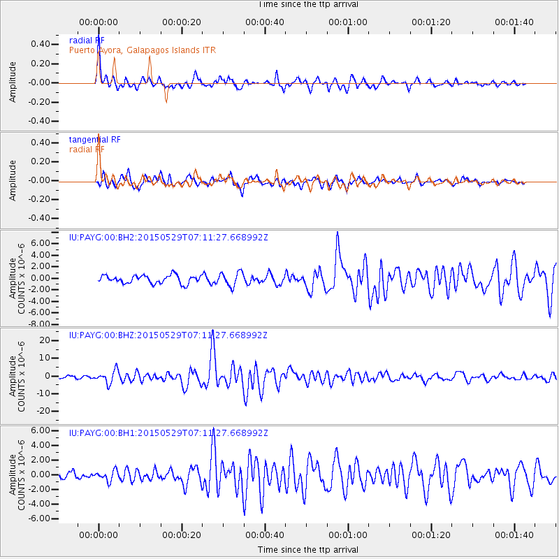
| IU:PAYG:00:BHZ:20150529T07:11:27.668992Z | 7.2291 | 3.6655754E-6 | 5.070583E-7 |
| IU:PAYG:00:BH1:20150529T07:11:27.668992Z | 1.5338923 | 7.0544047E-7 | 4.5990222E-7 |
| IU:PAYG:00:BH2:20150529T07:11:27.668992Z | 1.7818537 | 1.2438267E-6 | 6.980521E-7 |
| Arrivals |
| Ps | 3.5 SECOND |
| PpPs | 15 SECOND |
| PsPs/PpSs | 18 SECOND |


