You are here: Home > Network List > IU - Global Seismograph Network (GSN - IRIS/USGS) Stations List
> Station SFJD Sondre Stromfjord, Greenland > Earthquake Result Viewer
SFJD Sondre Stromfjord, Greenland - Earthquake Result Viewer
| Earthquake location: |
Alaska Peninsula |
| Earthquake latitude/longitude: |
56.7/-156.5 |
| Earthquake time(UTC): |
2015/05/29 (149) 07:00:08 GMT |
| Earthquake Depth: |
62 km |
| Earthquake Magnitude: |
6.8 MWP, 6.8 MI |
| Earthquake Catalog/Contributor: |
NEIC PDE/NEIC COMCAT |
|
| Network: |
IU Global Seismograph Network (GSN - IRIS/USGS) |
| Station: |
SFJD Sondre Stromfjord, Greenland |
| Lat/Lon: |
67.00 N/50.62 W |
| Elevation: |
330 m |
|
| Distance: |
45.0 deg |
| Az: |
32.332 deg |
| Baz: |
311.346 deg |
| Ray Param: |
0.07140069 |
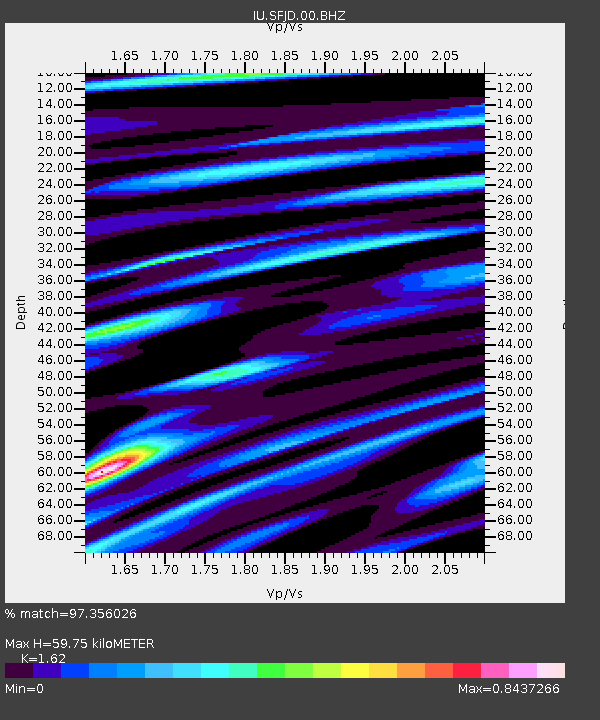
| Estimated Moho Depth: |
59.75 km |
| Estimated Crust Vp/Vs: |
1.62 |
| Assumed Crust Vp: |
6.459 km/s |
| Estimated Crust Vs: |
3.987 km/s |
| Estimated Crust Poisson's Ratio: |
0.19 |
|
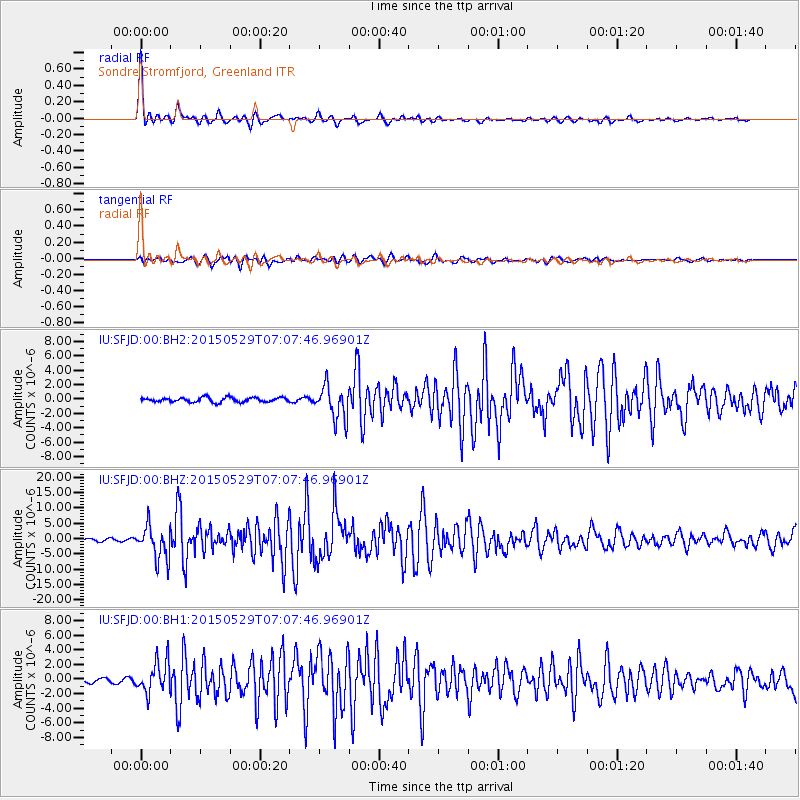
| Radial Match: |
97.356026 % |
| Radial Bump: |
343 |
| Transverse Match: |
90.28422 % |
| Transverse Bump: |
400 |
| SOD ConfigId: |
976571 |
| Insert Time: |
2015-06-12 07:15:44.712 +0000 |
| GWidth: |
2.5 |
| Max Bumps: |
400 |
| Tol: |
0.001 |
|
Signal To Noise
| Channel | StoN | STA | LTA |
| IU:SFJD:00:BHZ:20150529T07:07:46.96901Z | 19.21848 | 5.4345005E-6 | 2.8277472E-7 |
| IU:SFJD:00:BH1:20150529T07:07:46.96901Z | 8.410771 | 2.1430221E-6 | 2.5479497E-7 |
| IU:SFJD:00:BH2:20150529T07:07:46.96901Z | 7.5349603 | 2.3197413E-6 | 3.0786376E-7 |
| Arrivals |
| Ps | 6.2 SECOND |
| PpPs | 23 SECOND |
| PsPs/PpSs | 29 SECOND |


