You are here: Home > Network List > IU - Global Seismograph Network (GSN - IRIS/USGS) Stations List
> Station GRFO Grafenberg, Germany > Earthquake Result Viewer
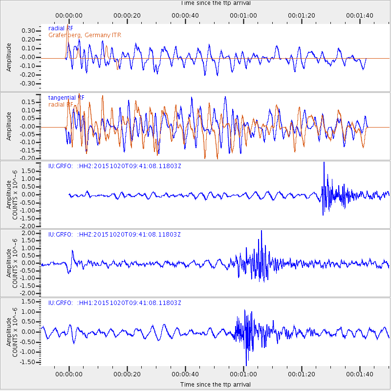
GRFO Grafenberg, Germany - Earthquake Result Viewer
*The percent match for this event was below the threshold and hence no stack was calculated.
| Earthquake location: |
Bonin Islands, Japan Region |
| Earthquake latitude/longitude: |
27.0/140.3 |
| Earthquake time(UTC): |
2015/10/20 (293) 09:29:08 GMT |
| Earthquake Depth: |
300 km |
| Earthquake Magnitude: |
5.5 MB |
| Earthquake Catalog/Contributor: |
NEIC PDE/NEIC COMCAT |
|
| Network: |
IU Global Seismograph Network (GSN - IRIS/USGS) |
| Station: |
GRFO Grafenberg, Germany |
| Lat/Lon: |
49.69 N/11.22 E |
| Elevation: |
384 m |
|
| Distance: |
91.2 deg |
| Az: |
329.701 deg |
| Baz: |
43.863 deg |
| Ray Param: |
$rayparam |
*The percent match for this event was below the threshold and hence was not used in the summary stack. |
|
| Radial Match: |
41.931313 % |
| Radial Bump: |
372 |
| Transverse Match: |
49.807083 % |
| Transverse Bump: |
400 |
| SOD ConfigId: |
7422571 |
| Insert Time: |
2019-04-21 04:02:13.900 +0000 |
| GWidth: |
2.5 |
| Max Bumps: |
400 |
| Tol: |
0.001 |
|
Signal To Noise
| Channel | StoN | STA | LTA |
| IU:GRFO: :HHZ:20151020T09:41:08.11803Z | 4.154146 | 3.5806278E-7 | 8.619407E-8 |
| IU:GRFO: :HH1:20151020T09:41:08.11803Z | 1.9525781 | 2.4581445E-7 | 1.2589224E-7 |
| IU:GRFO: :HH2:20151020T09:41:08.11803Z | 1.011801 | 8.16189E-8 | 8.066694E-8 |
| Arrivals |
| Ps | |
| PpPs | |
| PsPs/PpSs | |


