You are here: Home > Network List > KN - Kyrgyz Seismic Telemetry Network Stations List
> Station ULHL - > Earthquake Result Viewer
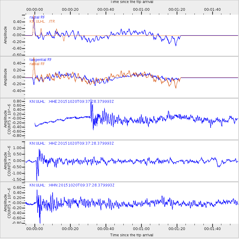
ULHL - - Earthquake Result Viewer
*The percent match for this event was below the threshold and hence no stack was calculated.
| Earthquake location: |
Bonin Islands, Japan Region |
| Earthquake latitude/longitude: |
27.0/140.3 |
| Earthquake time(UTC): |
2015/10/20 (293) 09:29:08 GMT |
| Earthquake Depth: |
300 km |
| Earthquake Magnitude: |
5.5 MB |
| Earthquake Catalog/Contributor: |
NEIC PDE/NEIC COMCAT |
|
| Network: |
KN Kyrgyz Seismic Telemetry Network |
| Station: |
ULHL - |
| Lat/Lon: |
42.25 N/76.24 E |
| Elevation: |
2040 m |
|
| Distance: |
53.6 deg |
| Az: |
304.012 deg |
| Baz: |
84.731 deg |
| Ray Param: |
$rayparam |
*The percent match for this event was below the threshold and hence was not used in the summary stack. |
|
| Radial Match: |
42.013424 % |
| Radial Bump: |
400 |
| Transverse Match: |
39.38236 % |
| Transverse Bump: |
400 |
| SOD ConfigId: |
7422571 |
| Insert Time: |
2019-04-21 04:02:28.097 +0000 |
| GWidth: |
2.5 |
| Max Bumps: |
400 |
| Tol: |
0.001 |
|
Signal To Noise
| Channel | StoN | STA | LTA |
| KN:ULHL: :HHZ:20151020T09:37:28.379993Z | 9.333654 | 5.125848E-7 | 5.491791E-8 |
| KN:ULHL: :HHN:20151020T09:37:28.379993Z | 4.988304 | 2.4032076E-7 | 4.8176844E-8 |
| KN:ULHL: :HHE:20151020T09:37:28.379993Z | 2.8328319 | 3.3313037E-7 | 1.17596244E-7 |
| Arrivals |
| Ps | |
| PpPs | |
| PsPs/PpSs | |


