You are here: Home > Network List > TA - USArray Transportable Network (new EarthScope stations) Stations List
> Station A36M Sachs Harbour, NT, CAN > Earthquake Result Viewer
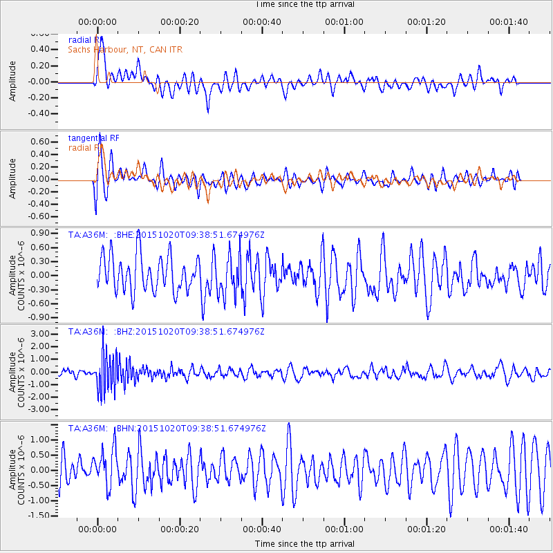
A36M Sachs Harbour, NT, CAN - Earthquake Result Viewer
*The percent match for this event was below the threshold and hence no stack was calculated.
| Earthquake location: |
Bonin Islands, Japan Region |
| Earthquake latitude/longitude: |
27.0/140.3 |
| Earthquake time(UTC): |
2015/10/20 (293) 09:29:08 GMT |
| Earthquake Depth: |
300 km |
| Earthquake Magnitude: |
5.5 MB |
| Earthquake Catalog/Contributor: |
NEIC PDE/NEIC COMCAT |
|
| Network: |
TA USArray Transportable Network (new EarthScope stations) |
| Station: |
A36M Sachs Harbour, NT, CAN |
| Lat/Lon: |
71.99 N/125.25 W |
| Elevation: |
32 m |
|
| Distance: |
65.9 deg |
| Az: |
19.859 deg |
| Baz: |
283.105 deg |
| Ray Param: |
$rayparam |
*The percent match for this event was below the threshold and hence was not used in the summary stack. |
|
| Radial Match: |
62.75986 % |
| Radial Bump: |
400 |
| Transverse Match: |
69.95828 % |
| Transverse Bump: |
400 |
| SOD ConfigId: |
7422571 |
| Insert Time: |
2019-04-21 04:04:42.819 +0000 |
| GWidth: |
2.5 |
| Max Bumps: |
400 |
| Tol: |
0.001 |
|
Signal To Noise
| Channel | StoN | STA | LTA |
| TA:A36M: :BHZ:20151020T09:38:51.674976Z | 3.7536926 | 1.4286519E-6 | 3.8059906E-7 |
| TA:A36M: :BHN:20151020T09:38:51.674976Z | 1.1325899 | 6.337645E-7 | 5.5957105E-7 |
| TA:A36M: :BHE:20151020T09:38:51.674976Z | 1.1444081 | 4.2904304E-7 | 3.7490386E-7 |
| Arrivals |
| Ps | |
| PpPs | |
| PsPs/PpSs | |


