You are here: Home > Network List > TA - USArray Transportable Network (new EarthScope stations) Stations List
> Station C06D Leavenworth, WQ, USA > Earthquake Result Viewer
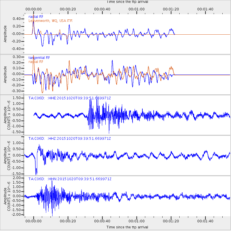
C06D Leavenworth, WQ, USA - Earthquake Result Viewer
*The percent match for this event was below the threshold and hence no stack was calculated.
| Earthquake location: |
Bonin Islands, Japan Region |
| Earthquake latitude/longitude: |
27.0/140.3 |
| Earthquake time(UTC): |
2015/10/20 (293) 09:29:08 GMT |
| Earthquake Depth: |
300 km |
| Earthquake Magnitude: |
5.5 MB |
| Earthquake Catalog/Contributor: |
NEIC PDE/NEIC COMCAT |
|
| Network: |
TA USArray Transportable Network (new EarthScope stations) |
| Station: |
C06D Leavenworth, WQ, USA |
| Lat/Lon: |
47.92 N/120.89 W |
| Elevation: |
544 m |
|
| Distance: |
76.0 deg |
| Az: |
43.238 deg |
| Baz: |
294.709 deg |
| Ray Param: |
$rayparam |
*The percent match for this event was below the threshold and hence was not used in the summary stack. |
|
| Radial Match: |
69.52119 % |
| Radial Bump: |
400 |
| Transverse Match: |
48.792988 % |
| Transverse Bump: |
400 |
| SOD ConfigId: |
7422571 |
| Insert Time: |
2019-04-21 04:04:47.737 +0000 |
| GWidth: |
2.5 |
| Max Bumps: |
400 |
| Tol: |
0.001 |
|
Signal To Noise
| Channel | StoN | STA | LTA |
| TA:C06D: :HHZ:20151020T09:39:51.669971Z | 3.7974787 | 6.19763E-7 | 1.6320381E-7 |
| TA:C06D: :HHN:20151020T09:39:51.669971Z | 2.0129328 | 2.9300534E-7 | 1.4556142E-7 |
| TA:C06D: :HHE:20151020T09:39:51.669971Z | 5.445912 | 6.0029214E-7 | 1.1022803E-7 |
| Arrivals |
| Ps | |
| PpPs | |
| PsPs/PpSs | |


