You are here: Home > Network List > TA - USArray Transportable Network (new EarthScope stations) Stations List
> Station H17A Grant Village (NPS), Yellowstone Nt. Park, WY, USA > Earthquake Result Viewer
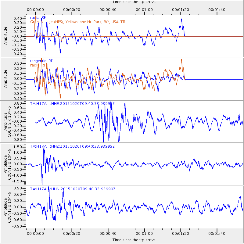
H17A Grant Village (NPS), Yellowstone Nt. Park, WY, USA - Earthquake Result Viewer
*The percent match for this event was below the threshold and hence no stack was calculated.
| Earthquake location: |
Bonin Islands, Japan Region |
| Earthquake latitude/longitude: |
27.0/140.3 |
| Earthquake time(UTC): |
2015/10/20 (293) 09:29:08 GMT |
| Earthquake Depth: |
300 km |
| Earthquake Magnitude: |
5.5 MB |
| Earthquake Catalog/Contributor: |
NEIC PDE/NEIC COMCAT |
|
| Network: |
TA USArray Transportable Network (new EarthScope stations) |
| Station: |
H17A Grant Village (NPS), Yellowstone Nt. Park, WY, USA |
| Lat/Lon: |
44.40 N/110.58 W |
| Elevation: |
2400 m |
|
| Distance: |
84.0 deg |
| Az: |
42.918 deg |
| Baz: |
302.084 deg |
| Ray Param: |
$rayparam |
*The percent match for this event was below the threshold and hence was not used in the summary stack. |
|
| Radial Match: |
60.324837 % |
| Radial Bump: |
400 |
| Transverse Match: |
56.3712 % |
| Transverse Bump: |
400 |
| SOD ConfigId: |
7422571 |
| Insert Time: |
2019-04-21 04:04:54.400 +0000 |
| GWidth: |
2.5 |
| Max Bumps: |
400 |
| Tol: |
0.001 |
|
Signal To Noise
| Channel | StoN | STA | LTA |
| TA:H17A: :HHZ:20151020T09:40:33.93999Z | 4.9415336 | 6.221886E-7 | 1.2591002E-7 |
| TA:H17A: :HHN:20151020T09:40:33.93999Z | 0.8140772 | 1.312141E-7 | 1.6118139E-7 |
| TA:H17A: :HHE:20151020T09:40:33.93999Z | 3.370141 | 3.206405E-7 | 9.514157E-8 |
| Arrivals |
| Ps | |
| PpPs | |
| PsPs/PpSs | |


