You are here: Home > Network List > TA - USArray Transportable Network (new EarthScope stations) Stations List
> Station N23A Red Feather Lakes, CO, USA > Earthquake Result Viewer
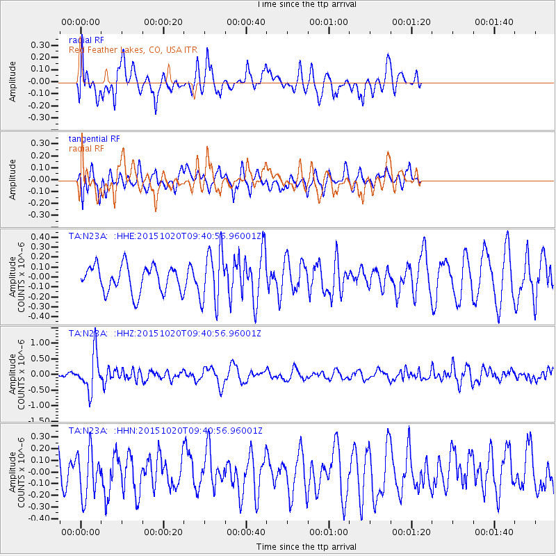
N23A Red Feather Lakes, CO, USA - Earthquake Result Viewer
*The percent match for this event was below the threshold and hence no stack was calculated.
| Earthquake location: |
Bonin Islands, Japan Region |
| Earthquake latitude/longitude: |
27.0/140.3 |
| Earthquake time(UTC): |
2015/10/20 (293) 09:29:08 GMT |
| Earthquake Depth: |
300 km |
| Earthquake Magnitude: |
5.5 MB |
| Earthquake Catalog/Contributor: |
NEIC PDE/NEIC COMCAT |
|
| Network: |
TA USArray Transportable Network (new EarthScope stations) |
| Station: |
N23A Red Feather Lakes, CO, USA |
| Lat/Lon: |
40.89 N/105.94 W |
| Elevation: |
2458 m |
|
| Distance: |
88.7 deg |
| Az: |
43.933 deg |
| Baz: |
305.278 deg |
| Ray Param: |
$rayparam |
*The percent match for this event was below the threshold and hence was not used in the summary stack. |
|
| Radial Match: |
43.514343 % |
| Radial Bump: |
400 |
| Transverse Match: |
60.88059 % |
| Transverse Bump: |
384 |
| SOD ConfigId: |
7422571 |
| Insert Time: |
2019-04-21 04:05:19.417 +0000 |
| GWidth: |
2.5 |
| Max Bumps: |
400 |
| Tol: |
0.001 |
|
Signal To Noise
| Channel | StoN | STA | LTA |
| TA:N23A: :HHZ:20151020T09:40:56.96001Z | 7.285202 | 6.0641E-7 | 8.3238604E-8 |
| TA:N23A: :HHN:20151020T09:40:56.96001Z | 1.313588 | 1.9730936E-7 | 1.5020643E-7 |
| TA:N23A: :HHE:20151020T09:40:56.96001Z | 1.9944724 | 2.6678825E-7 | 1.3376382E-7 |
| Arrivals |
| Ps | |
| PpPs | |
| PsPs/PpSs | |


