You are here: Home > Network List > US - United States National Seismic Network Stations List
> Station DGMT Dagmar, Montana, USA > Earthquake Result Viewer
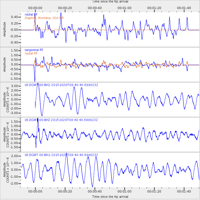
DGMT Dagmar, Montana, USA - Earthquake Result Viewer
*The percent match for this event was below the threshold and hence no stack was calculated.
| Earthquake location: |
Bonin Islands, Japan Region |
| Earthquake latitude/longitude: |
27.0/140.3 |
| Earthquake time(UTC): |
2015/10/20 (293) 09:29:08 GMT |
| Earthquake Depth: |
300 km |
| Earthquake Magnitude: |
5.5 MB |
| Earthquake Catalog/Contributor: |
NEIC PDE/NEIC COMCAT |
|
| Network: |
US United States National Seismic Network |
| Station: |
DGMT Dagmar, Montana, USA |
| Lat/Lon: |
48.47 N/104.20 W |
| Elevation: |
0.0 m |
|
| Distance: |
85.3 deg |
| Az: |
37.047 deg |
| Baz: |
306.149 deg |
| Ray Param: |
$rayparam |
*The percent match for this event was below the threshold and hence was not used in the summary stack. |
|
| Radial Match: |
57.726383 % |
| Radial Bump: |
400 |
| Transverse Match: |
63.730057 % |
| Transverse Bump: |
400 |
| SOD ConfigId: |
7422571 |
| Insert Time: |
2019-04-21 04:05:46.896 +0000 |
| GWidth: |
2.5 |
| Max Bumps: |
400 |
| Tol: |
0.001 |
|
Signal To Noise
| Channel | StoN | STA | LTA |
| US:DGMT:00:BHZ:20151020T09:40:40.699023Z | 1.6787812 | 8.164666E-7 | 4.8634485E-7 |
| US:DGMT:00:BH1:20151020T09:40:40.699023Z | 1.5481822 | 1.1610621E-6 | 7.4995177E-7 |
| US:DGMT:00:BH2:20151020T09:40:40.699023Z | 1.1120176 | 1.5826747E-6 | 1.4232461E-6 |
| Arrivals |
| Ps | |
| PpPs | |
| PsPs/PpSs | |


