You are here: Home > Network List > UW - Pacific Northwest Regional Seismic Network Stations List
> Station LEBA Lebam, WA, USA > Earthquake Result Viewer
LEBA Lebam, WA, USA - Earthquake Result Viewer
*The percent match for this event was below the threshold and hence no stack was calculated.
| Earthquake location: |
Bonin Islands, Japan Region |
| Earthquake latitude/longitude: |
27.0/140.3 |
| Earthquake time(UTC): |
2015/10/20 (293) 09:29:08 GMT |
| Earthquake Depth: |
300 km |
| Earthquake Magnitude: |
5.5 MB |
| Earthquake Catalog/Contributor: |
NEIC PDE/NEIC COMCAT |
|
| Network: |
UW Pacific Northwest Regional Seismic Network |
| Station: |
LEBA Lebam, WA, USA |
| Lat/Lon: |
46.55 N/123.56 W |
| Elevation: |
73 m |
|
| Distance: |
74.9 deg |
| Az: |
45.302 deg |
| Baz: |
293.274 deg |
| Ray Param: |
$rayparam |
*The percent match for this event was below the threshold and hence was not used in the summary stack. |
|
| Radial Match: |
48.735867 % |
| Radial Bump: |
400 |
| Transverse Match: |
50.381687 % |
| Transverse Bump: |
400 |
| SOD ConfigId: |
7422571 |
| Insert Time: |
2019-04-21 04:06:07.406 +0000 |
| GWidth: |
2.5 |
| Max Bumps: |
400 |
| Tol: |
0.001 |
|
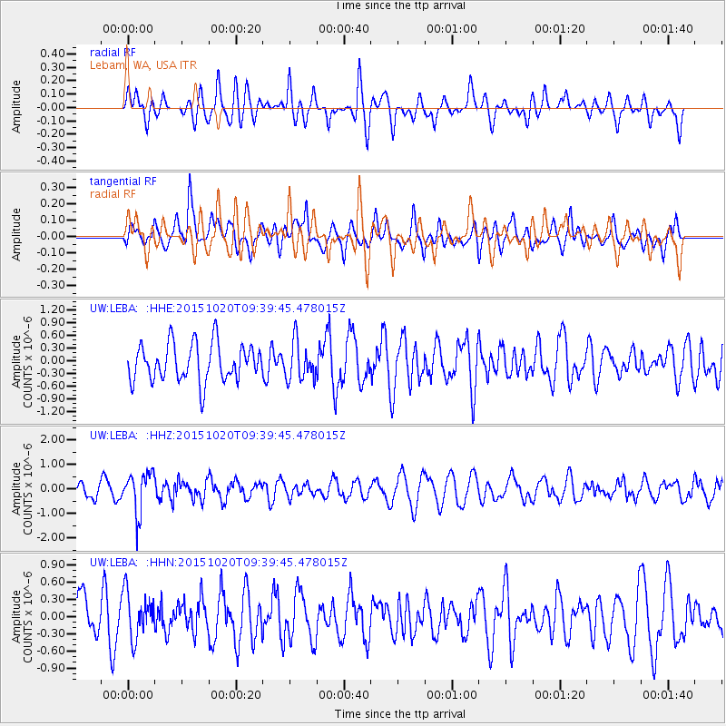
Signal To Noise
| Channel | StoN | STA | LTA |
| UW:LEBA: :HHZ:20151020T09:39:45.478015Z | 2.0264974 | 8.3607875E-7 | 4.1257334E-7 |
| UW:LEBA: :HHN:20151020T09:39:45.478015Z | 1.1428714 | 4.000011E-7 | 3.499966E-7 |
| UW:LEBA: :HHE:20151020T09:39:45.478015Z | 1.0132269 | 4.5010862E-7 | 4.4423282E-7 |
| Arrivals |
| Ps | |
| PpPs | |
| PsPs/PpSs | |


