You are here: Home > Network List > NE - New England Seismic Network Stations List
> Station PQI Presque Isle, ME, USA > Earthquake Result Viewer
PQI Presque Isle, ME, USA - Earthquake Result Viewer
| Earthquake location: |
Alaska Peninsula |
| Earthquake latitude/longitude: |
56.7/-156.5 |
| Earthquake time(UTC): |
2015/05/29 (149) 07:00:08 GMT |
| Earthquake Depth: |
62 km |
| Earthquake Magnitude: |
6.8 MWP, 6.8 MI |
| Earthquake Catalog/Contributor: |
NEIC PDE/NEIC COMCAT |
|
| Network: |
NE New England Seismic Network |
| Station: |
PQI Presque Isle, ME, USA |
| Lat/Lon: |
46.67 N/68.02 W |
| Elevation: |
162 m |
|
| Distance: |
52.1 deg |
| Az: |
60.775 deg |
| Baz: |
315.639 deg |
| Ray Param: |
0.06682716 |
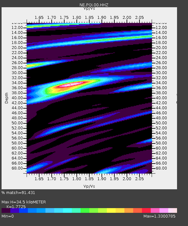
| Estimated Moho Depth: |
34.5 km |
| Estimated Crust Vp/Vs: |
1.77 |
| Assumed Crust Vp: |
6.419 km/s |
| Estimated Crust Vs: |
3.622 km/s |
| Estimated Crust Poisson's Ratio: |
0.27 |
|
| Radial Match: |
91.431 % |
| Radial Bump: |
400 |
| Transverse Match: |
88.22436 % |
| Transverse Bump: |
400 |
| SOD ConfigId: |
976571 |
| Insert Time: |
2015-06-12 07:17:23.226 +0000 |
| GWidth: |
2.5 |
| Max Bumps: |
400 |
| Tol: |
0.001 |
|

Signal To Noise
| Channel | StoN | STA | LTA |
| NE:PQI:00:HHZ:20150529T07:08:41.439011Z | 12.894964 | 2.0230398E-6 | 1.5688603E-7 |
| NE:PQI:00:HH1:20150529T07:08:41.439011Z | 4.1330247 | 5.7500847E-7 | 1.3912535E-7 |
| NE:PQI:00:HH2:20150529T07:08:41.439011Z | 6.4917755 | 6.37172E-7 | 9.815065E-8 |
| Arrivals |
| Ps | 4.4 SECOND |
| PpPs | 14 SECOND |
| PsPs/PpSs | 18 SECOND |


