You are here: Home > Network List > US - United States National Seismic Network Stations List
> Station AGMN Agassiz National Wildlife Refuge, Minnesota, USA > Earthquake Result Viewer
AGMN Agassiz National Wildlife Refuge, Minnesota, USA - Earthquake Result Viewer

| Earthquake location: |
Alaska Peninsula |
| Earthquake latitude/longitude: |
56.7/-156.5 |
| Earthquake time(UTC): |
2015/05/29 (149) 07:00:08 GMT |
| Earthquake Depth: |
62 km |
| Earthquake Magnitude: |
6.8 MWP, 6.8 MI |
| Earthquake Catalog/Contributor: |
NEIC PDE/NEIC COMCAT |
|
| Network: |
US United States National Seismic Network |
| Station: |
AGMN Agassiz National Wildlife Refuge, Minnesota, USA |
| Lat/Lon: |
48.30 N/95.86 W |
| Elevation: |
351 m |
|
| Distance: |
36.7 deg |
| Az: |
76.678 deg |
| Baz: |
306.49 deg |
| Ray Param: |
0.07634351 |
| Estimated Moho Depth: |
13.5 km |
| Estimated Crust Vp/Vs: |
2.10 |
| Assumed Crust Vp: |
6.419 km/s |
| Estimated Crust Vs: |
3.06 km/s |
| Estimated Crust Poisson's Ratio: |
0.35 |
|
| Radial Match: |
94.64311 % |
| Radial Bump: |
303 |
| Transverse Match: |
81.24386 % |
| Transverse Bump: |
400 |
| SOD ConfigId: |
976571 |
| Insert Time: |
2015-06-12 07:19:02.211 +0000 |
| GWidth: |
2.5 |
| Max Bumps: |
400 |
| Tol: |
0.001 |
|
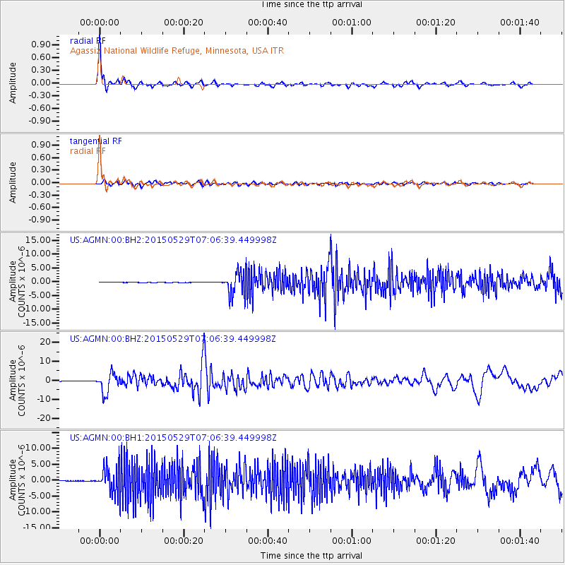
Signal To Noise
| Channel | StoN | STA | LTA |
| US:AGMN:00:BHZ:20150529T07:06:39.449998Z | 62.72381 | 5.1432935E-6 | 8.199906E-8 |
| US:AGMN:00:BH1:20150529T07:06:39.449998Z | 38.859467 | 4.003878E-6 | 1.0303483E-7 |
| US:AGMN:00:BH2:20150529T07:06:39.449998Z | 62.05441 | 4.1440635E-6 | 6.6781126E-8 |
| Arrivals |
| Ps | 2.5 SECOND |
| PpPs | 6.1 SECOND |
| PsPs/PpSs | 8.6 SECOND |


